


8/28/2022:
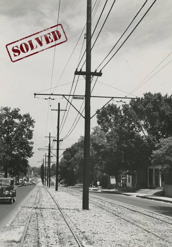
Today marks our final mystery in the summer series! For this week’s post, we’re taking a look at another section of the old trolley line. The description attached to this photograph states, “Power lines for trolley service running in median.” This section appears to be a more residential area of town, but it’s not clear where this photograph was taken.
Can you determine where this photograph was taken? Let us know in the comments box or click ‘Contact Us’ on DIG Memphis to provide any additional details you may know.
SOLVED!!
This mystery was solved over on our Instagram page. @paranan11 noticed the painted sign, partially visible on the building seen on the left side of the image. She was able to locate a ‘McKenney’s Grocery’ located at 553 S. Cooper Street.
Today, that spot is home to Juice Bar and Ounce of Hope (2022). The photographer was likely standing near the intersection of Vinton and Cooper, facing north.
The nearby coordinates for the image are 35.130306, -89.990528.
8/15/2022:
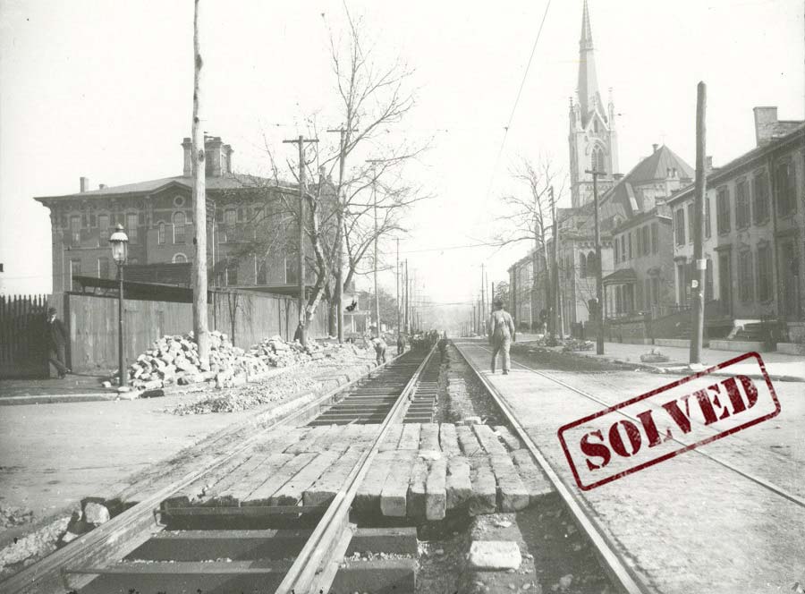
The title of the image above is simply, “Trolley tracks” and includes the description, “Laying of tracks for trolley system“, but where is this? What section of the trolley system is pictured here?
Using the details and buildings seen in the background of the photograph, can you determine where this photograph was taken? Please let us know in the comments box or click ‘Contact Us’ on DIG Memphis to provide any additional details you may know.
SOLVED!!
Several people submitted the answer to this one, both on the website and on our Instagram page. @b_m_boswell and @paranan11 both pointed to the church seen on the right side of the image.
Though the steeple was removed shortly after construction, St. Mary’s Catholic Church can still be seen in that same spot today!
That would place the photographer on Market Avenue, looking east from N. Second St. toward B. B. King Blvd: 35.151798, -90.048728.
8/08/2022:
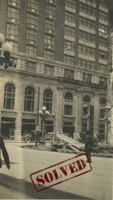
This week’s mystery comes to us with very little descriptive information. There’s no visible text in the image, and the description in the archive only states, “Construction materials on sidewalk. — Text on front: 53“. Text on the back of the photograph indicates the print was made in Memphis at the Memphis Photo Supply Co., but was the photographer in Memphis when this photograph was taken?
Can you help us determine if this is a photo of a building in Memphis? If so, where is this? If not, do you know which city this is? Please let us know in the comments box or click ‘Contact Us’ on DIG Memphis to provide any additional details you may know.
SOLVED!!
Instagram user @jnctb first cracked the case on this one, noting that the building pictured looked like the Exchange Building at the intersection of N. Second St. and Madison Avenue.
A second detective submitted a similar answer through the website, further confirming, “this is the Exchange Building located on the northwest corner of Madison and Second.”
The building remains in place, so we are able to confirm some of the architectural details seen in the image. The photographer was standing near the coordinates 35.144800, -90.051380.
7/25/2022:
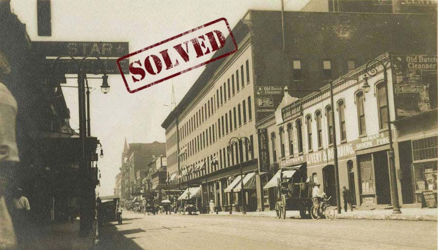
The description on the image above states, “Unidentified urban street. Text on front: 7/2/13”. So, is this Memphis? Based on the information found on the photograph, it’s likely the photograph was taken on July 2, 1913, but beyond that there are no further details. We don’t know what street this is or what direction we’re looking at in this image.
Can you help us determine if this street is located in Memphis? Were the businesses seen here known to be Memphis businesses in 1913? If you can crack the case, please let us know in the comments box or click ‘Contact Us’ on DIG Memphis to provide any additional details you may know.
SOLVED!!
This mystery was especially challenging because we were not sure if the street pictured was even in Memphis! @sunnyfranklin and @paranan11 cracked the case, answering our suspicions on our Instagram page.
Sunny Franklin was able to confirm this is Toledo, Ohio! In their 1913 city directory, there is a livery named A L Hofman’s located at 431-439 N. St. Clair Street. The 1913 directory also shows Union Paper Box Co. at 429-431 St Clair, which is likely the ‘Paper Boxes’ sign seen in the image.
Today this would be near where N. St. Clair St. intersects with Jackson Street. The photographer is looking southwest down St. Clair toward Adams. We can still see the large building on the right when viewing the Google Street View images! This would place the photographer near 41.653593, -83.532836.
7/18/2022:
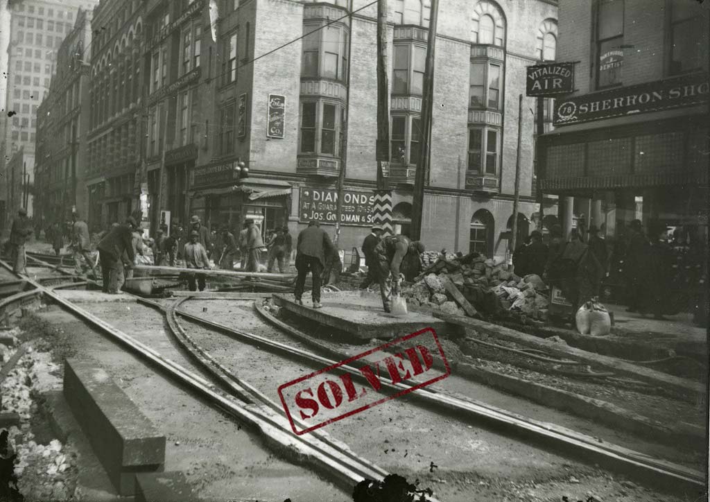
The description on the image above states, “Laying of tracks for trolley system on Main St.”, but there’s no further information specifying where along Main Street this photographer was standing. The signs on the buildings might give some clues as to what intersection is pictured here.
Can you help us locate which intersection is pictured here? Which direction is the photographer facing? Let us know in the comments box or click ‘Contact Us’ on DIG Memphis to provide any additional details you may know.
SOLVED!!
Many detectives submitted the correct answer to this one! K. Taylor and Joseph Hoyle both honed in on The Sherron Shoe Company, noting that it was once located at 78 South Main, which would place our location at the SE corner of Main and Union Avenue.
On our Instagram page, @sandytn, @natdnew @deltaarkieboi85 all further confirmed the location of the photograph as near the corner of Main and Union, facing north. @natdnew also pointed out that we can see the Washburn building, which is still standing today.
An anonymous submission also pointed out that the tall building seen in the background is 10 S. Main. All of these details place our photograph near the coordinates 35.143056, -90.053683.