


The Memphis/Shelby County Map and Poster Collection is located in the Memphis and Shelby County Room. The collection includes over 5000 maps and posters of local and regional interest. Here is a list of cataloged maps.
The poster collection includes Memphians During War (patriotic posters from World War I, World War II and other wars) and the Beale Street Collection (musical advertisement posters).
We’ve also pulled together this collection of online maps from various entities such as our own Dig Memphis digital archives, the Tennessee Virtual Library, and the Library of Congress:
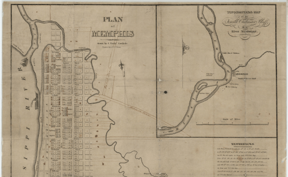
An 1854 reproduction of the 1819 plan for the city of Memphis, this map reflects the city at its founding as laid out by surveyor William Lawrence. Click for more:
In it, the city has a basic grid pattern with a few open areas. Some of which still exist today such as Court Square. In the upper right hand corner is a map of the general area with a few landmarks noted. Fort Pike refers to a fortification established by the U.S. Army in the 1790s. While Fort Pickering refers to a later fortification established further south. The U.S. government also set up an indian agency nearby. The names Judge Fooy and Paddy refer to two early settlers Dutch immigrant Benjamin Fooy and Irish immigrant Patrick Meagher. Source: Tennessee Virtual Archive
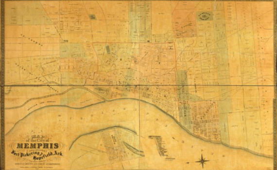
This detailed antebellum map shows the growth of a number of institutions in Memphis in the years before the Civil War. Click for more:
Among those shown are Elmwood cemetery, St. Agnes Academy, 2nd Presbyterian Church, St. Peter’s Church, and B’nai Israel. The last was the city’s first synagogue founded in 1854. Also shown are major antebellum hotels such as Gayoso House and Worsham House along with railroad lines such as the Memphis & Charleston. Source: Library of Congress
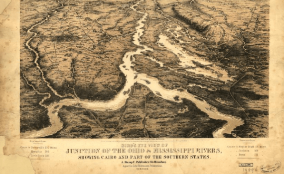
Bird’s eye view of junction of the Ohio & Mississippi Rivers, showing Cairo and part of the southern states (1861)
The above Civil War map shows the settlements on the Mississippi. Click for more:
It gives an overview of the small settlements around Memphis that existed in the 1860s such as Big Creek and Fort Pickering, Tennessee and Austin and Mound City, Arkansas. The map is laid out with north at the bottom of the map and south at the top. Memphis is located at the left bottom of the large bend in the river near the top of the page. Source: Library of Congress
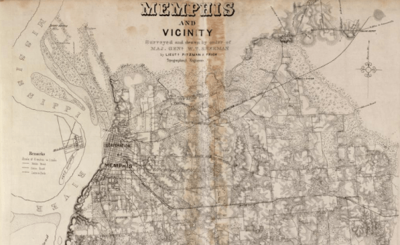
This is a Union Army map of Memphis drawn during the occupation of the city, which started in June 1862. Click for more:
General Sherman served as garrison commander in Memphis starting in July. However, the map is undated. Depicted are major strategic targets in the area such as railroads and fortifications. For example, the Memphis & Charleston railroad and Fort Pickering, the main Union garrison in the city, are shown. Lieutenants Julius Pitzman and Killian Frick created the map. Source: Library of Congress
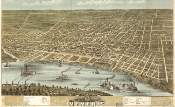
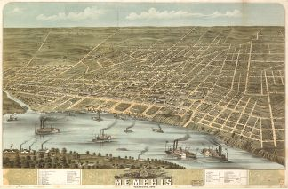
“Perspective map not drawn to scale.” This 1870 map is reasonably accurate. Most of the buildings and streets are drawn realistically. Source: Library of Congress
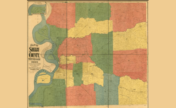
Though not detailed with regard to the layout of Memphis, the map shows the areas surrounding the city. Noted are land ownership at the time and major highways such as State Line, Pigeon Roost, and Old Raleigh roads. Source: Tennessee Virtual Archive
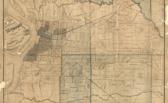
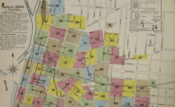
This map depicts Memphis just prior to the city’s first widespread yellow fever epidemic of the 1870s. Click for more:
Noted on the left side of the map is the Leath Orphan Asylum and the Colored Orphan Asylum a few streets over. As is the transfer ferry for the Memphis & Little Rock railroad across the Mississippi River. The first bridge at Memphis was constructed in 1892. Near the corner of Main and Monroe is marked the original Peabody Hotel, built in 1869. Civil districts are numbered. Circles radiate from Court Square indicating distance. Source: Tennessee Virtual Archive
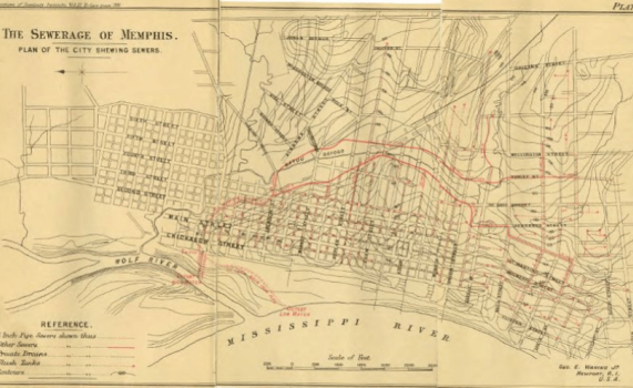
During this same period, the city was largely administered by the state government of Tennessee. Click for more:
Memphis had virtually declared bankruptcy in the wake of the worst epidemic in 1878, and the local government had asked the state to step in to help the city pay its debts. Despite a mountain of debt, the state and local governments made better sanitation a priority, resulting in the construction of a sewer system designed by George E. Waring, Jr. Source: Dig Memphis
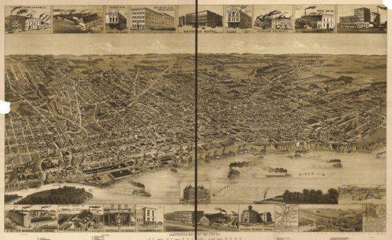
Perspective map not drawn to scale. Includes detailed drawings of many buildings. Click for more:
This map is somewhat less accurate than the similar perspective map from 1870. The artist took some liberties with the sizes of the buildings. However, it is still useful in determining the early layout and development of the city. Source: Library of Congress
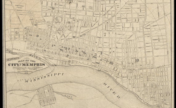
Provides detailed information on streets and structures. Source: Library of Congress
“Cadastral map showing the lot/block numbers and the names of residents.” Source: Library of Congress
Provides detailed information on streets and structures. Source: Library of Congress

F.W. Faxon & Co. Evergreen Map, 1904
This map depicts Memphis after major annexations giving the city almost a square shape. The map also depicts the development of the park system in Memphis showing Overton Park and Riverside Park. Further, the main transit system of the period, the city’s streetcar lines, are also depicted. The remnants of this system still exist today along Madison Avenue and Main Street. Source: DLynx Rhodes Digital Archive

Map of City of Memphis and Vicinity (1925)
This detailed color street map of Memphis and its immediate environs contains the names of landowners provided by Bluff City Abstract Co. Key institutions depicted for the first time include Rhodes College and the University of Memphis. On the map, they’re respectively labeled as Southwestern Presbyterian University and West Tennessee State Normal School. Rhodes moved to Memphis from Clarksville in 1925 while the University of Memphis was founded in 1912. Beyond this, the newly annexed Binghampton neighborhood is shown within the city limits for the first time. Binghampton had been its own town until annexation by Memphis in 1919. Source: Tennessee Virtual Archive

Railroads in Memphis, Shelby County, Tenn (1929)
“Map detailing the rail system in Memphis in 1929. Shows underpasses, overpasses, grade crossings with watchmen, and grade crossings with watchmen and gates. Also shown is Grand Central Station, Frisco Freight House, and Frames Island (present-day Mud Island). Major railroad lines running through Memphis include the Illinois Central, the Union Railway, the Nashville, Chattanooga & St. Louis Railway, the Southern Railway, and the Frisco Union Railway.” Source: Tennessee Virtual Archive

Ashburn Memphis Map, 1937
Created in 1937, this map shows the location of hospitals, public schools, and churches in the city. Major changes include Chickasaw Gardens and parts of East Memphis being shown as part of the city for the first time. Along with pieces of North Memphis and South Memphis, these areas were annexed by the city in 1929. The bottom of the map shows the municipal airport, which was established in 1927. Source: DLynx Rhodes Digital Archive

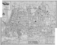
Ashburn’s Memphis Street Map (1951)
“Two sided tourist street map of Memphis showing schools, highways, parks, cemeteries and neighborhoods. Reverse side has a street guide index and advertising for Fischer Lime & Cement Co.” Source: Tennessee Virtual Archive
Memphis Street Ry. Co. (1955)
This is a map created by the Memphis Street Railway company, which ran the bus and streetcar systems during the 1950s. The map shows a distinct change in the cityscape with neighborhoods such as Chickasaw Gardens having winding streets as opposed to the previous grid pattern. That grid pattern predominates in areas such as Midtown. Since the earlier grid pattern had been ideal for using mass transit, the change reflects the widespread adoption of car culture in the city. Source: DLynx Rhodes Digital Archive
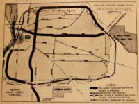
Interstate Highway Map (1958)
This map depicts a plan created by Harland Bartholomew and Associates for the interstate system in Memphis. However, authorities were only able to construct most of the system due to resistance by citizens groups to a section of I-40 running through Overton Park. Through a series of political and legal battles, they were able to successfully block the construction of that section. Much of which is documented in the Citizens to Preserve Overton Park collection in the Memphis Room. Because of their victory, modern day Sam Cooper Boulevard, which was originally supposed to be a section of I-40, terminates at the eastern edge of Overton Park. Source: Dig Memphis
We’ll be adding more as we can.