


DIG MEMPHIS MYSTERIES
2023 Mysteries – solved
check out some of the mysteries that have already been solved. IF YOU CAN HELP US with additional details, please submit information below!
updated mysteries!
DIG MEMPHIS MYSTERIES is a multi-week series of mysteries, all centered around a common theme. If you suggest an answer, please share with us how you solved the mystery. Include your name, and we’ll give you credit on the record in the DIG archives. To keep up to date with all DIG MEMPHIS MYSTERIES, follow us on Instagram at @digmemphishistory!
Fall 2023
10/23/2023:
This photo of an early football team comes with plenty of clues! The back of the photo includes a list of names: Row Bottom. L to R: Bill Turner, Lee Ford, Bill Aden, Harvey Luckelt(?). 2nd Row: Rex Latting, Burt Munson, (?) Fox, Bob Scrivener(?), Aex Yebron (?)-Standing. Back Row: Emery Shaplow, Bill Fowler [City Engineer], Lee McCourk [Fescher L. Cement Co.], Allen Sperry. Do you know what team these upside-down triangle and striped uniforms represent? Any idea what year this is?

SOLVED!!
We received a lot of helpful information from Hugh Lehman on this mystery. Well done! He, and a second anonymous submission, both pointed out that the players uniforms feature a prominent three-sided logo, which reflects the Spirit-Mind-Body Triangle of the YMCA, adopted as a logo in 1891. The Memphis YMCA fielded football teams from 1899-1908, with Luckett serving as captain around 1907-1908.
Mr. Lehman also noted that the nose guard equipment being worn around the neck of “Jno Fox” is a distinctive Penna or Morrill nose guard with a patented removeable mouthpiece (the very visible rectangle with three holes), which was not invented until May 1905. This helps date the photograph from sometime between 1905-1908.
We’ve also updated the record to include additional details about the men pictured here as part of the YMCA team. To read more of the new details, visit this item’s page on DIG Memphis!

Looking closely at the center of this image, we can tell this is another football team. Some of their uniforms match the upside-down triangles from photo 1. Do they play for the same team? The same school? Do you recognize any of the players? Can you tell us the year?
SOLVED!!
This mystery was also solved by Hugh Lehman. He noted that this exact photograph appeared appeared in The Commercial Appeal, December 4, 1955, section 2, page 12.
This is a photo of the YMCA football team. The year is 1904 and the players are: (Left to right) Front row: Bill Alexander, Allen Kelley
Middle row: Bill Turner, John Morgan Fox II (1887-1966), Lee Thomas Ford (1886-1962), Alex Gibson, Earl McQuistan
Back row: (unnamed coach), Allen Carr Sperry (1879-1968), Noble Stebbins Bruce (1886-1960), J. H. LeMay, Gilbert Mauss Schloss (1888-1960) – local sports star, coach of MUS, and president of the Memphis Associated Amateurs (1920), later an investment broker, Robert S. Schrivener (1881-1969), Julian Aymett (1883-1961), Leo Dorster, and Will Chandler

This photo holds a few mysteries. Our only clues can be found on their uniform logo which features the letter “M” in an upside-down triangle, inside a circle. Do you recognize those uniforms? What team do they play for? What sport do they play? Are any of those faces familiar to you?
SOLVED!!
Hugh Lehman provided helpful information on this mystery as well: Like Pictures #1 & 2, the triangle logo – this time with a circle – identifies this team as Memphis YMCA and several of the same players from the football team are here as well:
Middle row first from left is Allan Carr Sperry; Middle row third from left is John Morgan Fox II; Middle row fifth from left is Lee Thomas Ford.
Although there is no ball visible in the picture, the style of the tank top uniform suggests this is a photo of the Memphis YMCA Basketball Team circa 1907.
10/16/2023:

Included with this photo is a note that reads, “old dueling grounds, state line.” Perhaps this location is somewhere along State Line Road? Does this landscape look familiar to you? Do you know any historic Memphis dueling lore that could help us place this?
SOLVED!!
This mystery was solved through an anonymous tip on our website that suggested the road in the photo was near Dueling Oaks, an oak grove on the property of William Joyner, outside his mansion. Our anonymous tipper explained that duels were illegal in Tennessee so “participants traveled just across the state line to have a legal duel.” Another response from our website backed them up: “I expect the road is current day Highway 51. The dueling grounds were just across the Mississippi line from what is today Whitehaven.”
We confirmed that this is the location with a 1974 article from the Commercial Appeal. The article retells the story of the last duel fought at Dueling Oaks between accountant Edward Freeman and lawyer Edward Hamlin, the final Memphis dueling victim. The article pulls from an 1870 account of the duel which describes an old field on Joyner’s land which is now where Highway 51 crosses the Mississippi line—proving our tippers right!
10/09/2023:
Today’s #MysteryMonday photos came from a folder of historic photographs of Memphis Buildings taken by Poland Photographers. While the folder included easily recognizable images like the Peabody Hotel, there were a number of buildings that were difficult to identify. This week’s mystery focuses on three unidentified buildings. Included below are the details of what we know about each image and what we need your help to uncover!

In this first image, the sign on the building reads, “University of Tennessee, Institute of Pathology.” We’re not sure where this building was. Do you recognize the street? What direction would the photographer be facing?
SOLVED!!
We received a few clues on this mystery in the comments of our Instagram post. This building was the University of Tennessee Institute of Pathology, and we were not sure where it was located. Instagram user @paranan11 suggested the building was at 858 Madison and that the building was still there. They were backed up by @girleight who added that the photo was taken from 869 Madison.
After poking around Google Maps, we confirmed that both of these users were right! Looking from 869 Madison, attempting to get the slightly angled perspective of the original photo, reveals that while the building is no longer the Institute of Pathology, 858 Madison seems to maintain some of the original building from our photo. Additionally, it is still used by the University of Tennessee. Though it is now the Molecular Process Building.
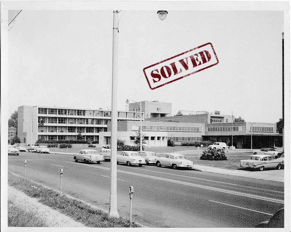
This image is a little trickier. We’re not sure what street it is on nor what building is photographed. Does anything in this image look familiar to you?
SOLVED!!
This mystery was solved by a suggestion from @aggietoo on our Instagram page. She posted that perhaps the building was the old Le Bonheur Hospital, and in fact, it is! Searching the Commercial Appeal archives led to an article from 1952 covering the opening of the new hospital, and including an image of the hospital from this same angle.
Searching DIG Memphis for “Le Bonheur” brings up additional photographs of the original building, all looking quite similar to the photograph here. That would place our photographer near the coordinates: 35.143773, -90.033088.
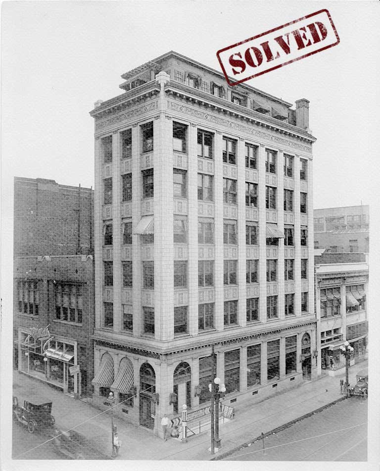
While we don’t know the name of the downtown building in this final image, we do know that it housed American Savings Bank & Trust Company and Merry Optical Co. Can you use the clues in the image to help identify the street or building? Where would the photographer have been standing to take the photo?
SOLVED!!
This was solved on Instagram thanks to the sharp eye of @great_white_schark and backed up by @paranan11 and @girleight. They identified the location of the building as the northeast corner of Madison Ave and Second Street by perusing the vintage postcards on historicmemphis.com and discovering that the building was “the Germania Bank Building, which replaced the Masonic Temple, and then was replaced by the Blake Building.”
We further confirmed the location using Commercial Appeal’s archives and found a 1931 advertisement for a Manhattan Savings Bank & Trust at Second and Madison, which tracks with the visible sign on our original image that reads American Savings Bank & Trust (though there seems to be a slight name change). The illustration in the ad looks similar to the building as well. Further, the newspaper ran a history of this particular corner in a 1982 article in the Business Section of the paper.
Unfortunately, that gorgeous mysterious building is no more, replaced with a modern brown structure. Which you can see in the Google Street View Image.
Summer 2023
8/21/2023:
This week’s mystery photograph shows wagons lined up outside the offices of D. Canale & Co., wholesale fruit and produce merchants in Memphis.
The printed caption at the bottom of the image reads: “Side View: Showing convenience in handling less than carload freight in and out.” A handwritten note on the back reads: “182.” Where was D. Canale & Co.? Where was the photographer standing and pointing the camera when this image was made? If you can find the answers, let us know in the comments box!
SOLVED!!
Several people submitted answers for this mystery, providing us with a lot of helpful information! First, a detective named Patrick submitted the following information, “This building is at 408 S. Front Street. The photographer was standing on the north west corner of S. Front street and Huling when the photo was taken. The building is still there today and is now the Paperworks apartments.”
This is correct! Using Google Street View we can confirm this location is accurate. Further, we received a submission from an anonymous detective giving us the correct coordinates: 35.136156, -90.059592. Another submission gives a little more detail about the building today – “In January 1987, this building became the Paperworks Apartments (a Henry Turley development) with an address of 408 S. Front Street.” And because they were a resident of the Paperworks building, also included this interesting tidbit, “The southernmost neighbor was Selph’s Cricket Ranch (420 S. Front), a three story building that, I was told, incubated 35 million crickets annually!”
8/14/2023:
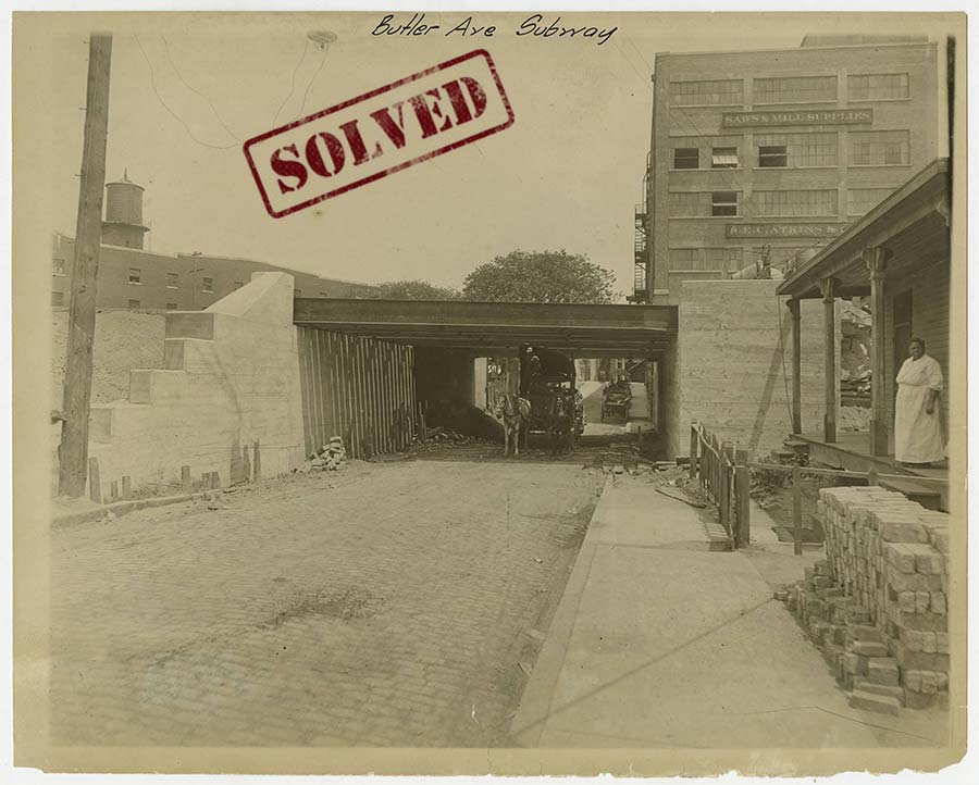
This week’s mystery photograph provides a fair number of clues. According to accompanying notes, the picture shows an underpass on brick-paved Butler Avenue in 1914. A woman is standing on the porch of a house at the right. Signs on the building in the background identify it as E. C. Atkins & Co. Saws & Mill Supplies.
The handwritten caption at the top reads: “Butler Ave. Subway.” An tag attached to the physical photograph reads: “Illinois Central Railroad Co. Office of Photographer, Chicago, Ill. May 21, 1914 Negative by J. K. Melton.” Analyzing all of that information should give us a pretty good idea of where the photographer was standing. Can you help locate the portion of Butler Ave. where this photograph was taken and the direction the photographer was standing?
SOLVED!!
A few people solved this one! First, Patrick Tarpley submitted information proving that this photo was taken while the photographer was standing on Butler looking east between Front street and Main street. As Mr. Tarpley, explained, “the large brick building on the right in the background is the Arrive Hotel today on the corner of Butler and Main street.“
Another anonymous detective noted the sign on the large brick building on the right, stating that “Atkins was located at #477 South Main Street in 1914.” This further proves that the building on the right is the current location of the Arrive Hotel (previously a Memphis College of Art graduate school building). The photographer, then, would have been standing at about 35.134500, -90.060247.
8/7/2023:

The title of this image is simply, “Residential Street.” The description gives a little more information, including the fact one of the mailboxes has a name and number visible: H.E. Padgett, with the number 3814. However, we were unable to determine the street name at the time this item was digitized. If you can provide any additional information about the street or H.E. Padgett, please let us know in the comments box!
SOLVED!!
This mystery was solved by an anonymous submission. Someone was able to find information in the Commercial Appeal Archive from June 17, 1949, stating that Mr. and Mrs. H.E. Padgett lived at 3814 Woodland Drive, putting this photograph near the location of 35.1329893,-89.9342527.
7/31/2023:

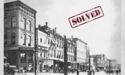
We’re heading downtown for this week’s mystery. This 10 x 3.5 in. photograph shows an industrial street in downtown Memphis. A locomotive and a horse-drawn cart are visible near an intersection. The building on the corner has a painted sign reading, “Barnes & Miller” – likely, Barnes & Miller Hardware Company.
We don’t know the date this photograph was taken, nor are there any notes indicating exactly where the photographer was standing when this image was captured. If you can help by providing more specific information about the location in the photograph or the date it was taken, please let us know in the comments box!
SOLVED!!
We received several submissions on this mystery. One anonymous submission suggested that it was taken, “around 90-145 Nettleton Ave. looking towards Front Street. Other sources say this is from 1910.” This was backed up by users on Instagram, who also indicated that the building at the corner of Nettleton Ave. and Front Street later housed the Piggly Wiggly Headquarters.
The 1909 City Directory indicates that the NW corner of Front Street and Nettleton was a construction site. In the 1910 Directory, Barnes & Miller Hardware is listed as occupying the space, where it remains until 1914. The building still stands today and can bee seen on Google Maps: 35.135017, -90.059671.
7/24/2023:
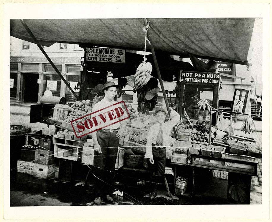
This week’s mystery photograph shows a young man and a boy in front of a produce stand covered by an awning. A sign on top of the cash register reads “A. Campagna.” Signs on the windows of a building in the background read “Hunt & Bro.” and “…Express Company”.
The handwritten description on the back of this photograph reads, “Names unknown” and “Gift of P. L. Campagna, Jr.” Unfortunately, it is undated. Can you help determine the location pictured here? Perhaps the businesses in the background will provide a clue. If you can figure it out, let us know in the comments box!
SOLVED!!
Instagram user @sunnyfranklin solved this mystery, pointing out that newspaper articles provide a “treasure trove of fascinating facts” about the Campagna family, including the location of their fruit stand.
The City Directories give a variety of locations for the stand, all around Court Square: SW Corner of Main/Court, NE Corner of Main/Court, and finally 20 N Main in 1934. As @sunnyfranklin pointed out, the building in the background, with the windows indicating a business in the basement do match up with the Dr. D. T. Porter building at 10 N Main.
And in fact, newspaper advertisements and the City Directories from 1909, indicate that Hunt & Bro. was located in the basement level of the Porter Building. Further, the American Express Co. was located at 103-105 Court Avenue, which corresponds to the signs seen in the background of the image. The Commercial Appeal archive also has a 1912 story discussing the Compagna fruit stand and describes it as being at the SW corner of Court Square.
All of these details help to place our photographer at the SW corner of Court Square, looking south toward the Porter Building located at 10 N. Main: 35.145750, -90.052428.
Winter 2023
2/27/2023:
This week’s mystery will be the final one in our Winter series. We’ll be taking a break to process all of the submissions and update archival records, but first, one final photograph from the Robert Lanier Collection.
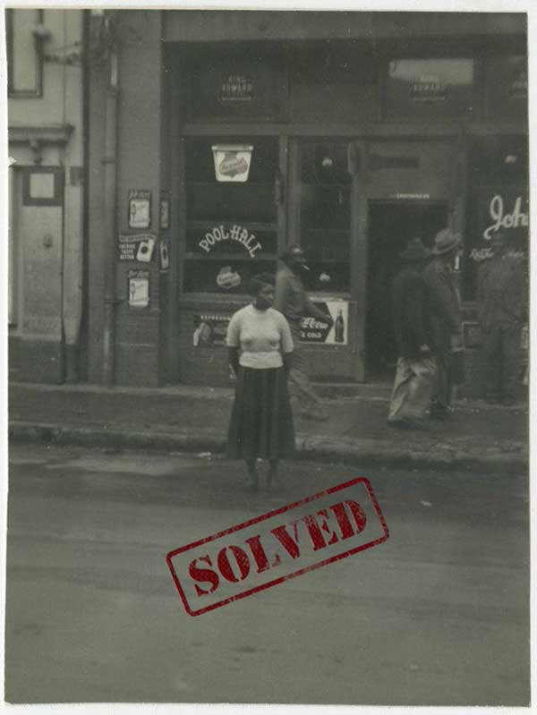
The description accompanying this photograph reads, “A photo of a woman standing in the street outside a pool hall on Beale Street.” The date is 1955. Can you help us locate this pool hall? What Beale Street address is this? If you can figure it out, let us know in the comments box!
SOLVED!!
This week’s mystery was solved by our Instagram followers. One detective noted that the building on the left edge of the frame matches the details on The Daisy Theatre, which would place the pool hall at 323 Beale.
Others noted that the location is still a pool hall today! Peoples on Beale currently occupies the location. These details place our photographer around 35.139406, -90.050404.
1/30/2023:
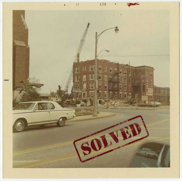
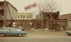
The title given to this photograph in our archive is “Building near Union”, but the description indicates that information is not conclusive. All we know is that it’s “a photo featuring construction around an apartment house or hotel, possibly on Union Avenue.”
Is this construction or a demolition? Is this building located on Union or perhaps a nearby street? If you know, please let us know in the comments box!
SOLVED!!
This was solved through a collaborative effort. Several detectives sent in parts of the answer. Over on Instagram several people concurred that the intersection of Dunlap and Union is what was captured in the photograph. But looking in which direction?
Instagram user @mistr.kay elaborated that it appeared the photographer was standing alongside Health Sciences Park, looking across to Union. @b_m_boswell followed up suggesting the demolition was to make room for the UTHSC Dental building.@lesaispas concurred that the location was near what used to be the College of Social Work.
We received one submisstion through the website from a detective named Patrick, who summed up the findings nicely: “The building in the picture was located on the south east corner at the intersection of Union and South Dunlap street next door to the Scottish Rite Cathedral building. Today it is occupied by the UT Dental/Orthodontics building. There is a corner of a building, the University of Tennessee Health Science O.W. Hyman building, showing on the left side of the photo which can be seen on the google maps street image at this location.”
All of these details help to place our photograph near 35.138688, -90.033775.
1/23/2023:
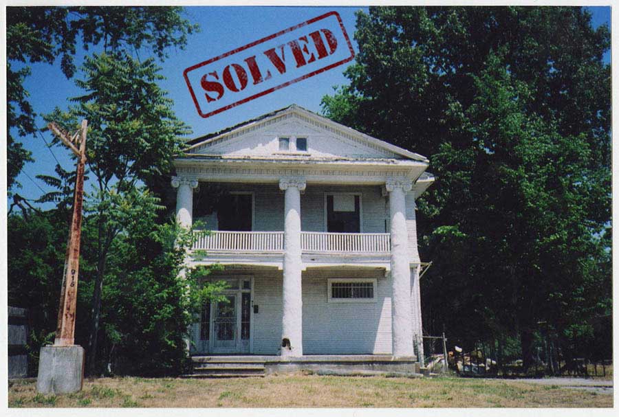
This week’s mystery photograph is another from our Robert Lanier Collection. Unlike many of our previous mysteries, this photo was taken fairly recently. The date on the image is May 20, 2008. The description only states, “A photo of the front of a white house. The light pole has the number 916 on it.”
We’re not sure what neighborhood this is or the street where this house is/was located. Can you help? If you recognize this house and can provide more details about where it is located, let us know in the comments box!
SOLVED!!
This mystery was solved both on our Instagram account and through submissions on the web. The first submission we received incated that the home is at 916 Rayner Street, and though the home has been remodeled, the pole with the address is still there today.
@whattangledwebs on Instagram used Google Maps to confirm the location as 916 Rayner Street, placing the photograph around 35.120924, -90.011704.
1/09/2023:
The first photo for today’s Monday Mystery is simply titled, “Memphis house”. The accompanying data indicates the photograph was taken on February 11, 1969. When the photo was first digitized, the description included stated, “a photo of a historic Memphis house, possibly on Vance Avenue.”
Is this Vance Avenue? Do you recognize this house? If so, please let us know! We’re interested in learning where this home was located and where the photographer was standing when the image was captured. Let us know your thoughts in the comments box!
SOLVED!!
This mystery was solved on our Instagram page. Memphis magazine published an article by Vance Lauderdale titled, “Lost Memphis: Henderson Business College”. In the article Vance Lauderdale describes finding an old booklet from 1950 which turned out to be the “Official Catalogue” of Henderson Business College, located at 530 Linden. The brochure includes a photograph of the above building, with the caption: “DORMITORY FOR GIRLS”. This puts the photographer around: 35.136762, -90.044522.
Explore more mysteries:

Resources:
Here are some resources that can help with your search.
City Directories 1849-1943 – Shelby County Registrar (link)
Commercial Appeal Archives 1894-Today – ProQuest(link)
Historic Shelby County – Aerial Maps (link)
Maps of Memphis (link)
Vehicle Registration Plates of TN – Wikipedia (link)