


DIG MEMPHIS MYSTERIES
2020 Mysteries – solved
check out some of the mysteries that have already been solved. IF YOU CAN HELP US with additional details, please submit information below!
If you submit additional details, please include your name, and we’ll give you credit on the item record.
12/14/2020:
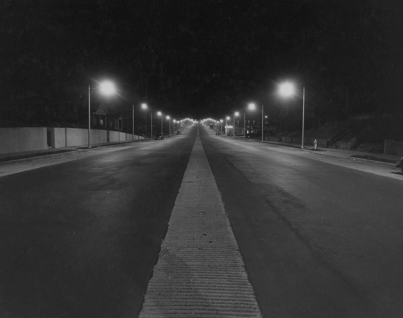
As a final mystery for 2020, this photograph (our cover image) has yet to be solved. It shows an empty Crump Boulevard at night. Marchesini & Co. Bakery is visible on the right. Can you determine where and when this photograph was taken?
SOLVED!!
This mystery has been solved by Sunny Franklin over on our Instagram page! She pointed out that the city directory places Marchesini & Co bakers at 297 E H Crump Blvd E. and found records of the bakery as early as 1914 at 297 E Iowa Avenue (which was Crump Blvd.’s previous name). The last entry found for the bakery is in 1958 being run by the Zavell family. Also in the directory, is the name Latham Sandwich Shop, at 295 E Iowa, and in fact, if we zoom in on the photograph above, the word ‘sandwich’ is partially visible, followed by the word ‘shop’, just below the Marchesini sign! This puts our photographer looking east along Crump Blvd., standing between Third Street and Latham St.: approximately 35.124551, -90.053837.
[expand title=”Click here to share additional details!”] — [/expand]
11/23/2020:
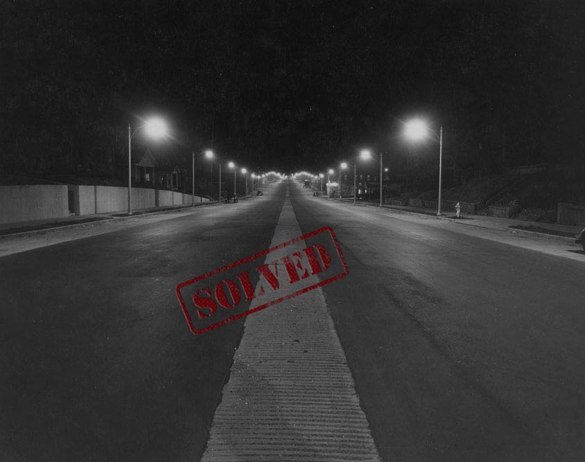
Here’s a photograph from an unusual perspective. The caption on top of photograph appears to say, “Poplar St From Roof.” The caption on bottom reads, “R111-2-2.” So, we’re looking at Poplar Avenue from the roof of structure, but where. Where would this photographer be standing today?
SOLVED!!
This mystery has been solved by Josh Eddleman over on our Instagram page! He pointed out that DIG Memphis has a large collection of photographs from this home as part of the Mayor Family Mini-Collection in our Pink Palace Photograph Collection. The home, owned by the Mayor family, was located at 1556 Poplar Avenue.
Our photographer was facing south, looking toward Poplar Avenue from the roof of the home, at approximately 35.143724, -90.008682.
[expand title=”Click here to share additional details!”] — [/expand]
11/02/2020:
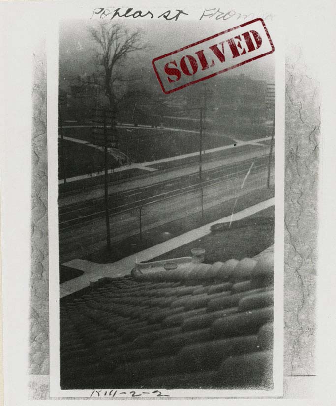
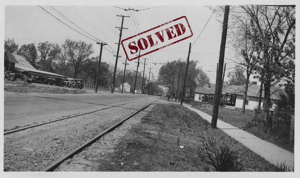
This undated photograph shows McLean Boulevard surrounded by trees. The only description given on the digital record is, “Looking south down McLean Boulevard.” Can you pinpoint this spot?
SOLVED!!
Another mystery solved on our Instagram page! Phoebe Moore suggested two things leading to the solution. One, she suggested looking into resurfacing projects or projects that involved the creation of railroad overpasses, and two, she pointed to the image in Street0477, which appears to be a companion photograph. That photograph also captures McLean, but facing north from Evelyn. In the image we see the same business sign and railroad crossing signs as in Street0476, suggesting they were taken at the same time in an effort to document upcoming construction.
An article in the Commercial Appeal, date November 23, 1936 discusses the construction of a “subway” under the N.C. & St. L. railroad, which crossed McLean between York and Evelyn. This 1925 map shows the spot being discussed in the article.
This places our photographer on McLean, just south of Central Avenue, near the coordinates 35.125975, -90.001521.
[expand title=”Click here to share additional details!”] — [/expand]
10/26/2020:
Many of the remaining mystery photographs in our Memphis Streetscapes Collection depict areas undergoing various types of construction. This image of Castalia Street from 1938 is one such example. Taken in May of 1938, the photograph includes a caption on the back, stating, “Castalia – before resurfacing.” Can you pinpoint this location on Castalia Street?
SOLVED!!
This mystery was first solved on our Instagram page. Emily Baum noted that the intersection looked like Castalia and Carnes. She pointed out that you can still see the two houses on the right, and the second house from the corner on the left is also still there! Phoebe Moore added further confirmation, stating, “if you zoom in on the utility pole on the right, near the intersection, it looks like the cross street name begins with “C” which would be Carnes.”
This places our photographer on Castalia Street, between Lamar Avenue and Carnes Avenue, near the coordinates 35.113100, -89.994910.
[expand title=”Click here to share additional details!”] — [/expand]
10/19/2020:
This photograph is a challenge to locate due to the lack of notable structures or signs. The description on the digital records simply reads, “Traffic on Hollywood Avenue and fields surrounding.” The date is also unknown. If you are able to locate this spot along Hollywood Avenue and/or the time period in which the photograph was taken, please let us know below!
SOLVED!!
This mystery was solved by Glenn Bandy. He noticed that if you zoom in on the photo you can see the Cypress Creek bridge. Cypress Creek is the only creek crossing Hollywood in NE Memphis. He also pointed to the silver tank structures on the right. These can be seen on a 1938 Aerial map and on any current map. They are a part of Buckeye Cotton Seed Oil at Chelsea and the ICRR.
Looking beyond the Cypress Creek crossing, we can also make out a railroad crossing sign, and in fact, there was a railroad crossing along Hollywood, just north of Cypress Creek. The 1938 Aerial map notes it as the Louisville & Nashville Railroad.
This places our photographer on Hollywood Street, just south of Dana Drive (the aerial map shows markings for the planned neighborhood), near the coordinates 35.161314, -89.975771.
[expand title=”Click here to share additional details!”] — [/expand]
10/12/2020:
Taken in 1956, this photograph captures construction workers along Dunn Avenue. The description on the digital record states, “A photo of construction workers on Dunn Avenue building what appears to be a sidewalk and street curbs. Houses line the right side of the street, with a fenced-in building on the left.” Can you determine where this construction project was located along Dunn Avenue?
SOLVED!!
This mystery was very quickly solved by Taylor Clay. He used the 1949 aerial map to confirm that this is the intersection of Dunn Avenue and Airways Boulevard. The map shows the houses on right, which is north side of Dunn, and the large building on the left is also visible. Using Google Street View we can still see the power lines, high voltage towers, fencing, and the hill along south side of Dunn today. This location was confirmed by Glenn Bandy, who pointed out “the shadow in the foreground of the traffic light” and Phoebe Moore, who placed our photographer near 35.091583, -89.987861.
[expand title=”Click here to share additional details!”] — [/expand]
10/05/2020:
This image shows Riverside Drive while it was under construction. The caption on the back of the photograph simply reads, “Riverside Drive (to be tarred) 6-38.” Where along Riverside Drive was our photographer standing in 1938?
SOLVED!!
This was another mystery first solved on our Instagram page. Sunny Franklin pointed out that based on the two mounds in the photograph, this spot is in what is now known as Chickasaw Heritage Park, specifically on what is now Metal Museum Drive, in front of the Metal Museum, looking southeast. An article in the Commercial Appeal on July 12, 1938 describes construction going on in this area at the time, saying, “With the aid of WPA funds, the Engineering Department has built a new drive beginning at Wisconsin Street extending along California Avenue north of De Soto Park and west and south around the park to Wisconsin Street.” This would put the photographer around the coordinates: 35.122982, -90.075364.
[expand title=”Click here to share additional details!”] — [/expand]
09/28/2020:
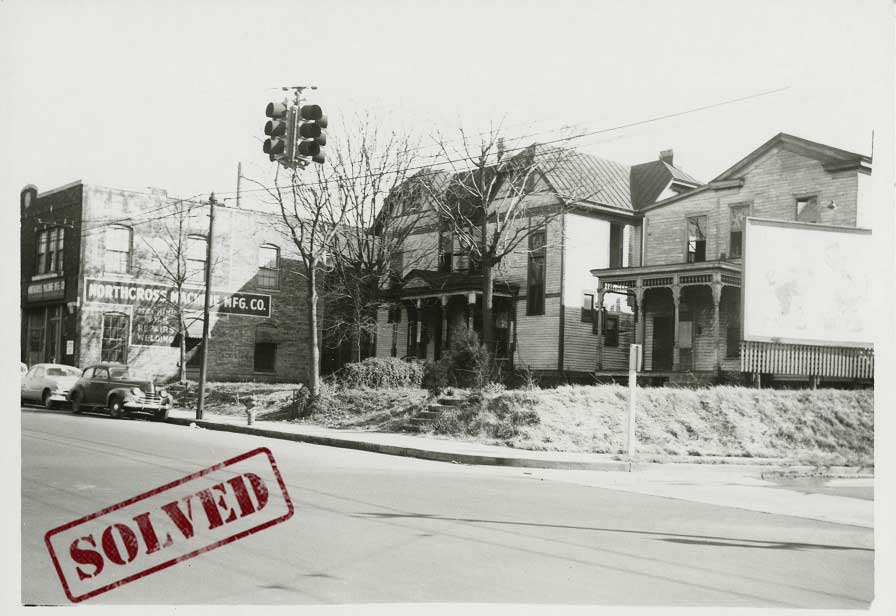
This image shows Northcross Machine Mfg. Co. on Madison Avenue, and the record indicates that the photograph was taken in 1950. Where along Madison Avenue was Northcross Machine Mfg. Co. located?
SOLVED!!
This mystery was solved by Phoebe Moore and confirmed by Caroline Carrico. Both pointed to a 1944 advertisement in the Commercial Appeal indicating that Northcross Machine Manufacturing was located at 385 Madison Avenue. Phoebe also stated, “The Sanborn Fire Insurance map from 1950, Vol. 3 seems to indicate that [Northcross] is the 385 Madison building – and that those two residences next to it were torn down.”
The 1949 aerial shows the two residences, which an anonymous detective stated “are possibly rooming houses owned by a Thomas E. Jordan and listed as 381 and 383 Madison.” Our anonymous detective further confirmed the location using the 1948 City Directory, saying, “Northcross Machine Manufacturing Company was at 385 Madison. Owned by two brothers- Leon and Wilson Northcross who also owned Northcross Tile and Marble listed at 388 Madison and Northcross Mantel and Grate Co at 411 Madison.”
This suggests the photograph was taken shortly before the two residences were demolished and puts the photographer near the corner of Madison and Wellington, pointing the camera toward the south side of Madison between Wellington & Lauderdale: 35.142896, -90.044131.
[expand title=”Click here to share additional details!”] — [/expand]
9/21/2020:
The markings on the back of this photograph indicate that it was taken on April 18, 1936 and depicts Chelsea Avenue before the street underwent a paving project. The description does not include any more specific information that would let us know where on Chelsea Avenue this spot is located. Are you able to determine where the photographer was standing back in 1936?
SOLVED!!
Phoebe Moore was the first to submit the solution to this mystery! She first pointed to a July 15, 1935 article in the Commercial Appeal archive that discussed an upcoming PWA project repaving Chelsea from Bellevue to Evergreen. Focusing her efforts on that area, she pointed to the 1938 Aerial Map, which shows a large building shaped like the one on the left with lots of cars around it near the intersection with Sylvan (Chelsea Auto Yard). This would place the photographer just east of Sylvan Street, looking west.
Glenn Bandy later confirmed this location by consulting the 1938 Aerial Map. He noted that the brick two story build in the background on the left can be seen in the aerial map at the corner of Chelsea and Bellevue. Further, by using Google Street View, we can see that the house on the right side of Chelsea is still there! You can see it on the western side of the Sylvan/Chelsea intersection, placing our photographer around 35.171365, -90.016246.
[expand title=”Click here to share additional details!”] — [/expand]
9/14/2020:
This photograph, taken in the 1960s, depicts an intersection in the Medical Center district; however, without any visible street signs we were unable to include the exact geographic coordinates. By examining the buildings in the background, are you able to determine which intersection this is? If so, please let us know!
SOLVED!!
We received the first answer to this mystery on our Instagram page. Chase Wyatt quickly identified this as the intersection of Madison Avenue and Dudley Street, looking west on Madison Avenue, and he noted that the building on the left is the old Baptist Hospital. Phoebe Moore also pointed out Baptist Hospital, and added that the building in the background on the left is the Physicians’ and Surgeons’ Building. This would place the photographer at 35.140140, -90.029531.
[expand title=”Click here to share additional details!”] — [/expand]
8/24/2020:
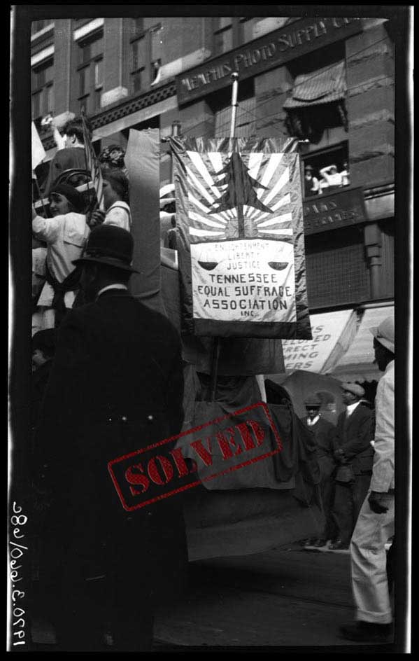
100 years ago today, on August 24, 1920, Tennessee Governor Albert H. Roberts certified the state’s ratification of the 19th Amendment, sending it on to Washington, D.C. to be officially enshrined in the U.S. Constitution. So, for today’s mystery we’re highlighting one of the images from our Votes for Women online exhibit.
The description on the photograph states, “Women on a float bearing sign, ‘Tennessee Equal Suffrage Association, Inc.’ in front of Memphis Photo Supply on S. Main Street.” What building is this? Where was Memphis Photo Supply Company?
SOLVED!!
Phoebe Moore was the first person to solve this mystery. She noted that Memphis Photo Supply Company had multiple address over the years, including 151 Union Ave. and 126 Monroe Ave. In 1915, this business was located at 60 S. Main. Today that building is known as The Washburn, and when comparing the stone work and dentil detail it looks like a match!
Caroline Carrico further confirmed this location by pointing to an ad found in the Commercial Appeal on September 30, 1920 (page 8), which also lists the address as 60 S. Main Street. That would place our photographer around the coordinates: 35.143530, -90.053477.
[expand title=”Click here to share additional details!”] — [/expand]
8/3/2020:
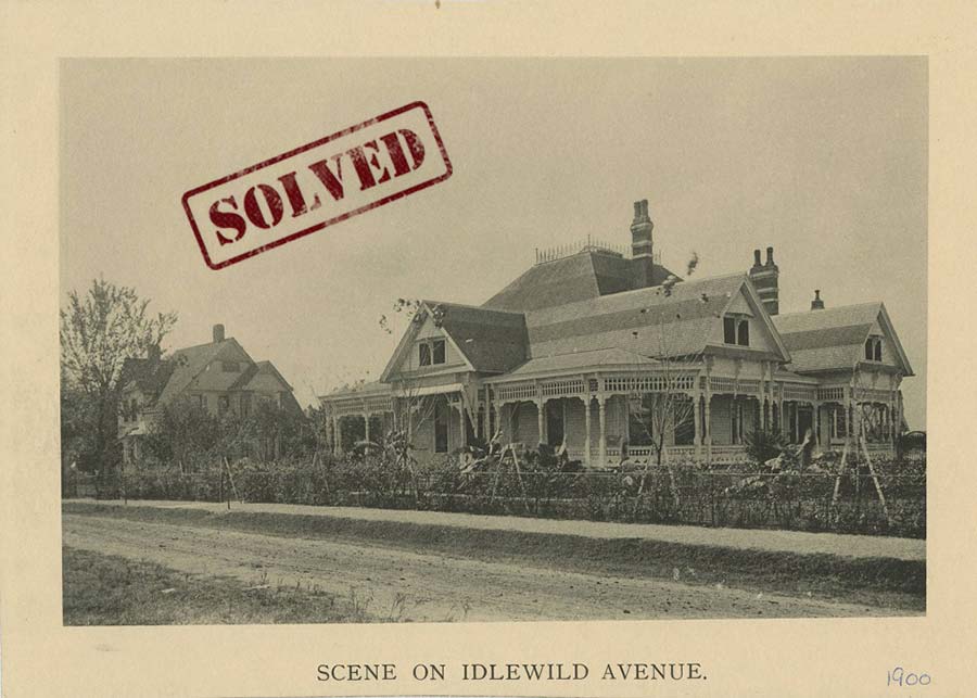
“Idlewild Avenue”. Memphis Streetscapes Collection, DIG Memphis. (Digital ID Street0527)
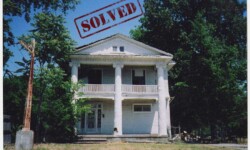
The above image is another photograph that is part of the series showing old homes from around the turn of the 20th century. This on depicts a scene on an unpaved Idlewild Avenue. Are you able to recognize any of the old homes seen here?
SOLVED!!
This mystery was solved by Phoebe Moore, who consulted the 1907 Sanborn Map for the answer. From the map, she noticed, “[it] shows a house that appears to have the same shape as this one – with the split porches that wrap around the sides, on a large lot – there is also a greenhouse in the back yard, which would have likely been necessary for those palms.” The house on the map is located on the southwest corner of Madison Avenue and Idlewild, with the address 9 S. Idlewild. In 1900 it belonged to Henry Luerhmann; it appears he purchased the lot in 1896.
If the address 9 S. Idlewild is correct, then the house in the background would be 15 S. Idlewild, and is still standing! You can see some of the same details in the Google Street View of the image. That would place the photographer near 35.137684, -90.001109.
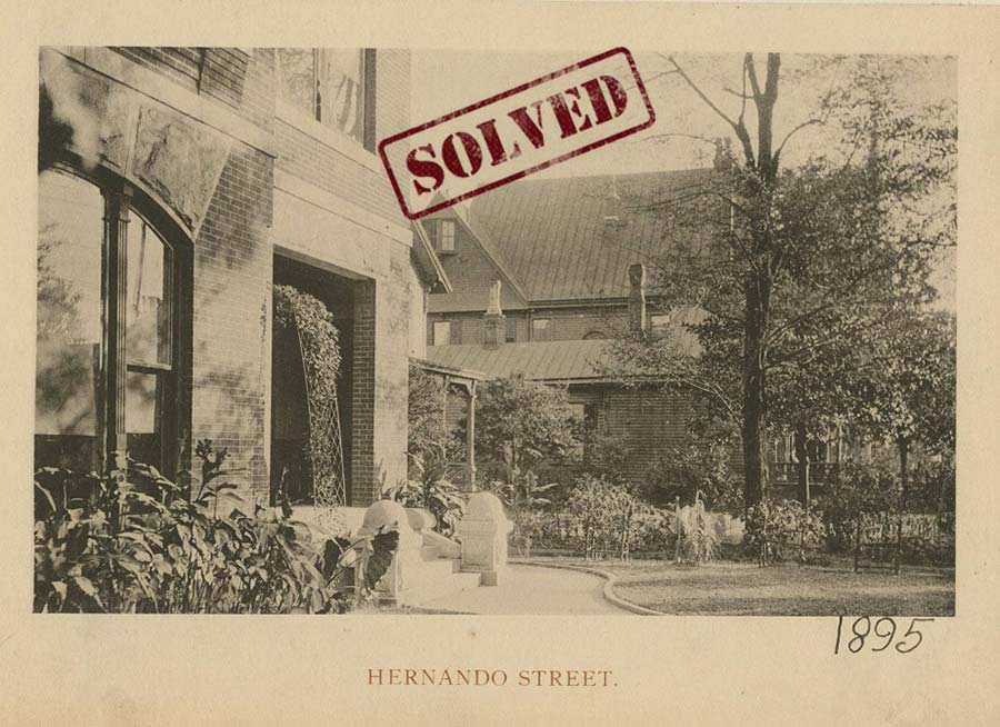
This 1895 photograph shows homes along Hernando Street. The age of the image and the placement of the camera make this mystery especially difficult to solve. We do not see many details of the homes; however, it is possible other photographs exist showing this area of Hernando Street. If you recognize where these homes would be located today, let us know!
SOLVED!!
This mystery was also solved by Phoebe Moore, who consulted the 1907 Sanborn Map for the answer. From the map, she noticed, “it looks like there is only one brick residence that is set back from the street like that – it would be 161 Hernando. It’s on page 134 of Volume 2 of the 1897 map.” That would place our photographer near the coordinates: 35.136430, -90.051530.
7/27/2020:
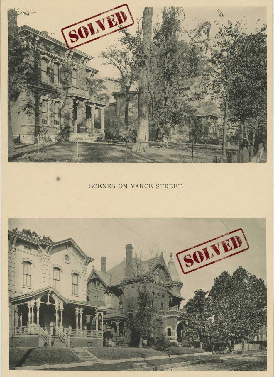
These two pictures show Victorian-era houses on Vance Avenue around the turn of the 20th century. Can you determine where these homes were located?
SOLVED!!
This mystery was solved by an online sleuth who spent some time searching our digital archive and discovered two additional copies of the above images. The photographs seen in Digital ID Street0963 and Digital ID Street0962 portray the same houses seen above, but also include descriptive information, handwritten on the front of the photograph. The homes in the top image are accompanied by a note stating, “Cynthia to So. Orleans”, and the note for the two on the bottom reads, “Lauderdale to Cynthia”.
Our detective took that information and consulted the Sanborn Fire Map of 1897. When looking at the Sanborn map (and the color-coordinated key), they determined that the structures in the top images were labeled 414 and 430 on Sanborn map, which would place the photographer around 35.134405, -90.040846.
The two homes seen in the bottom image are labeled 362 and 364 on the Sanborn map, placing the photograph of that image around 35.134645, -90.043291.
[expand title=”Click here to share additional details!”] — [/expand]
7/20/2020:
This image of Jackson Avenue was taken in 1960. We can see several businesses with signs along the road, but no numbered addresses are visible. Can you determine what spot this is along Jackson Avenue?
SOLVED!!
We received multiple submissions for this mystery – both here and on our Instagram page! Online sleuths were able to place this image as being near Memphis National Cemetery, around Orchi Road. One person used our access to the Commercial Appeal Archives to locate the Esso station seen in the photograph. “It’s Rook’s Esso at 3671 Jackson Ave.” Another pointed out that a couple of the buildings are still there! “The Esso station in this photograph is [now] a closed down engine shop, but the pump island is still there. Although obscured by trees, the two metal buildings also remain, a part of Jimmy Whittington’s lumber. Where the J.B. Cook sign is, is 3675 Jackson, current home of Crown Supermarket.”
Rickey White on Instagram (@rickeywhite11) supplied an exact address for our photographer’s location, stating, “my Mother lived EXACTLY where this photographer was standing. She lived in an old farmhouse and the address was 3702 Jackson Ave. They tore her house down in the early 1970’s to build what was called Dean’s Carpets, now called Carpet Spectrum.”
Thanks to all of the information supplied we can determine that the photographer was standing near the coordinates: 35.178192, -89.937324.
[expand title=”Click here to share additional details!”] — [/expand]
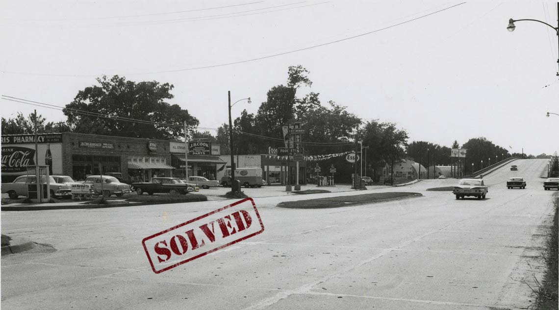
This photograph, titled “Jackson Avenue”, appears to show the same area as the one in the image above, but taken at a different time. We can also see a Texaco station on the opposite side of the street. Examining the two photographs and the businesses depicted in each, can you locate this spot?
SOLVED!!
As one online detective said, “This is about 3672 Jackson Avenue. The metal building in the background (on Chelsea) still remains!” That puts the photographer around: 35.177388, -89.937969, facing southbound.
[expand title=”Click here to share additional details!”] — [/expand]
7/13/2020:
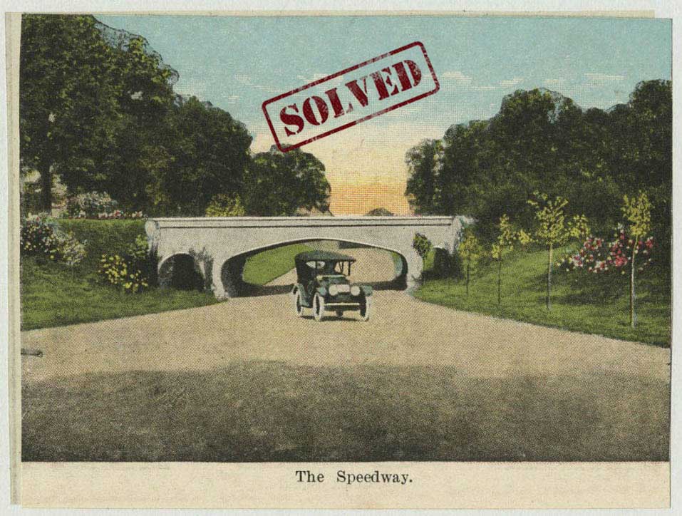
This postcard from around 1921 simply reads, “The Speedway”. As part of our Memphis Streetscapes Collection, the image should be pinned to a specific spot on our Streetscapes map of Memphis, but we don’t currently have any geographic data on the record. Can you help us determine what spot is depicted in this image?
solved!!
This mystery was solved over on our Instagram page! Paige Sanderson (@thepaigesanderson) first directed us to a Memphis Magazine article where Vance Lauderdale discusses The Speedway, specifically, “that the postcard manufacturers of the day (many of them out-of-town firms) often confused North Parkway with East Parkway. As a result, quite a few postcards supposedly showing “The Speedway” actually depict East Parkway, not North.” The article even references our postcard from above. This leads to the question, “where is this on East Parkway?”
StoryBoard Memphis (@storyboardmemphis) cracked the case! They noticed that there was another image in DIG Memphis (Digital ID Street0791) that was possibly the inspiration for the postcard, putting this spot looking “north at the point where the Nasvhille-Chattanooga & St. Louis Railroad crosses East Parkway”. Further research turned up another copy of the postcard (Digital ID post393), this one with writing on the back saying, “R. R. bridge over East Parkway in front of Christian Brothers College.” This matches the spot described by Storyboard Memphis! You can see the railroad crossing on this 1925 map.
The coordinates for the above image are roughly: 35.129143, -89.983828.
[expand title=”Click here to share additional details!”] — [/expand]
7/6/2020:
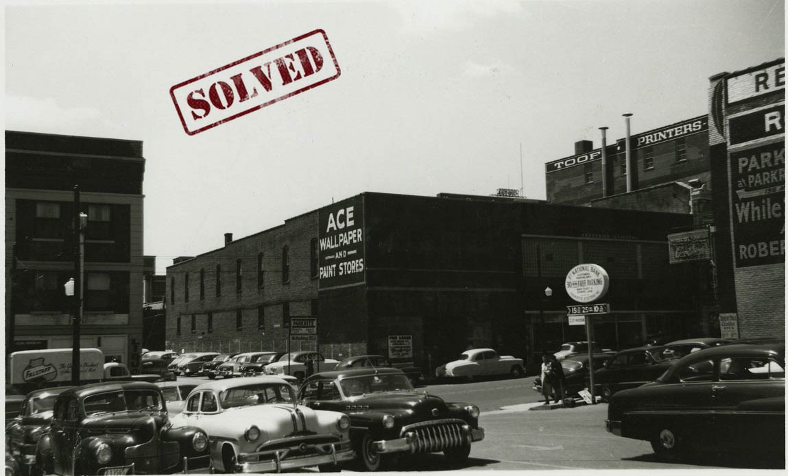
This photograph of Madison Avenue was taken in 1953. The description in our archive states, “Business signs on Madison Avenue, including: Toof Printers and Ace Wallpaper and Paint Stores”; however, the exact location has not been added to our records. Can you help determine the coordinates and/or street address of the buildings seen here?
solved!!
We received multiple answers to this mystery! The first two anonymous responses pointed out that the Toof Printers building is now the Pressbox Lofts at 195 Madison Avenue. According to the 1943 Polk Directory, Toof Printers was located at 195-201 Madison, placing the photographer across the street, which was listed as a parking lot. In fact, we do see a parking sign indicating a lot owned by 1st National Bank.
Glenn Bandy further confirmed this location, providing us with coordinates and a specific detail: if you look at the front walk of the Toof Building today, at the door you’ll see that the SC Toof logo is still there! Caroline Carrico added additional details, referencing a Commercial Appeal article from August 29, 1948 (pg. 23), which reported a theft at Ace Wallpaper and Paint Stores, locating the store at 219 Madison Avenue. Today, that location is part of Autozone Park.
Our final anonymous detective pointed to the building on the right edge of the photo where we see “RE..” in paint. This would be the “Red Feather Building”, located in the block east of the Sterick Building, as seen in past postcards. All of the evidence points to our photographer being near the coordinates: 35.1442829, -90.0488155.
[expand title=”Click here to share additional details!”] — [/expand]
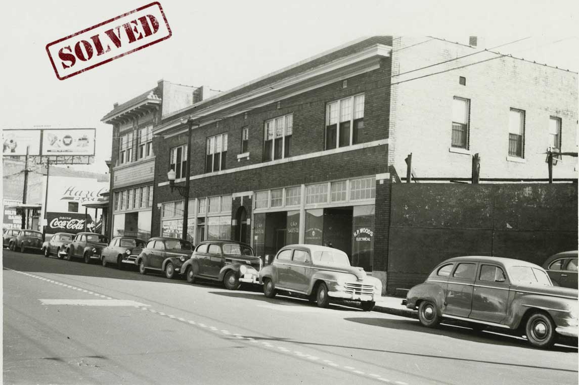
This 1950 photograph shows another area of Madison Avenue, lined with automobiles and businesses. Our records do not currently include geographic information for this image. Can you determine where the photographer was standing when this picture was taken?
SOLVED!!
Although the data accompanying this photograph indicates it was taken in 1950, the 1943 City Directory offered the first clue to this location. We received an anonymous tip that the 1943 Directory lists a Harold P. Woods, electrical repair shop at 401 Madison Avenue, between Wellington and Lauderdale.
Phoebe Moore also found information pointing to this block of Madison Avenue. She noted an entry in a magazine called The Billboard from 1950; it listed C&P Sales as being at 407 Madison. When examining that block today, it’s clear none of the buildings remain. However, the building on the southeastern corner of Madison and Lauderdale is still there, and it is visible on the very left side of the photograph above. That means our photographer was standing near the coordinates: 35.142647, -90.043335.
[expand title=”Click here to share additional details!”] — [/expand]
6/22/2020:
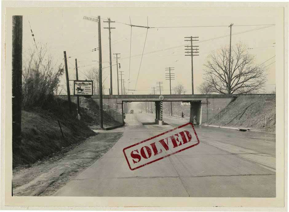
The record accompanying this image does not have have a date, and the description simply reads, “An overpass over Lamar Avenue.” Do you know where this overpass is located?
solved!!
We received a many submissions for this one, with many people adding in extra interesting details. Our first anonymous tip pointed to the sign on the left, showing “Allied Mills Inc. 2205 Lamar”, and noted that the drain to the right as well as the driveway to the left are still there . This address for Allied Mills, Inc. is confirmed in the 1943 Polk Directory. This information was confirmed by Glenn Bandy, who also found evidence of Allied Mills being at 2205 Lamar.
A second anonymous sleuth provided additional details. A Commercial Appeal article from December 5, 1986 discusses a new sign for United Equipment, purchaser of the property at 2205 Lamar, and in fact Google Street View currently shows image the United Equipment sign on a structure at this address. Jim McCall elaborates, saying, “the Allied Mills sign depicts the side entrance to the Allied Mills Grain Elevator which still stands but the “Allied Mills” on the elevator was painted over in the late 80’s when United Equipment occupied the property. The old grain elevator is still painted with United logo and has been abandoned for years.”
All of these details helped place the photographer at about 35.108384, -89.988606.
[expand title=”Click here to share additional details!”] — [/expand]
This photograph, taken on November 15, 1950, is described as, “View of East McLemore Avenue”. Our records do not include any specific coordinates or cross streets. Can you help determine what stretch of East McLemore is shown in this photograph?
solved!!
We received a many submissions for this mystery as well, each adding different information. Our first anonymous submission stated that this was the Union Pacific railroad overpass near Wilson Avenue and pointed to the 1943 Polk Directory and the 1951 Ashburn Street Map for confirmation. An imprint of the old track can be seen by the current satellite image, and matches what is seen in the Ashburn Map.
Glenn Bandy confirmed this location and pointed to the advertisement sign on the right side of the image, which he noted was an ad for Missouri Pacific RR (later the Union Pacific). The logo on the sign is the same on the overpass. He also pointed out that on Google Street View you can still see the embankment for the overpass, just west of Wilson Avenue. Phoebe Moore further confirmed it’s location using the 1938 and 1949 Aerial maps.
Our last piece of information came from another anonymous detective, who added that “the overpass was presumably taken up somewhere in the early 1950’s along the same time that Missouri Pacific abandoned the track at East Parkway and Central Avenue (the site of a larger bridge that bears great resemblance to this one). According to Josh Whitehead of SmartCityMemphis.com, the East Parkway bridge’s ‘trestle was finally removed in the early 50s once Missouri Pacific (Union Railway’s parent) was granted access on the railroad line immediately to the north. The old tracks were pulled up and the railroad right-of-way abandoned.'”
All of these details helped place the photographer at about 35.115598, -90.017814.
[expand title=”Click here to share additional details!”] — [/expand]
6/29/2020:
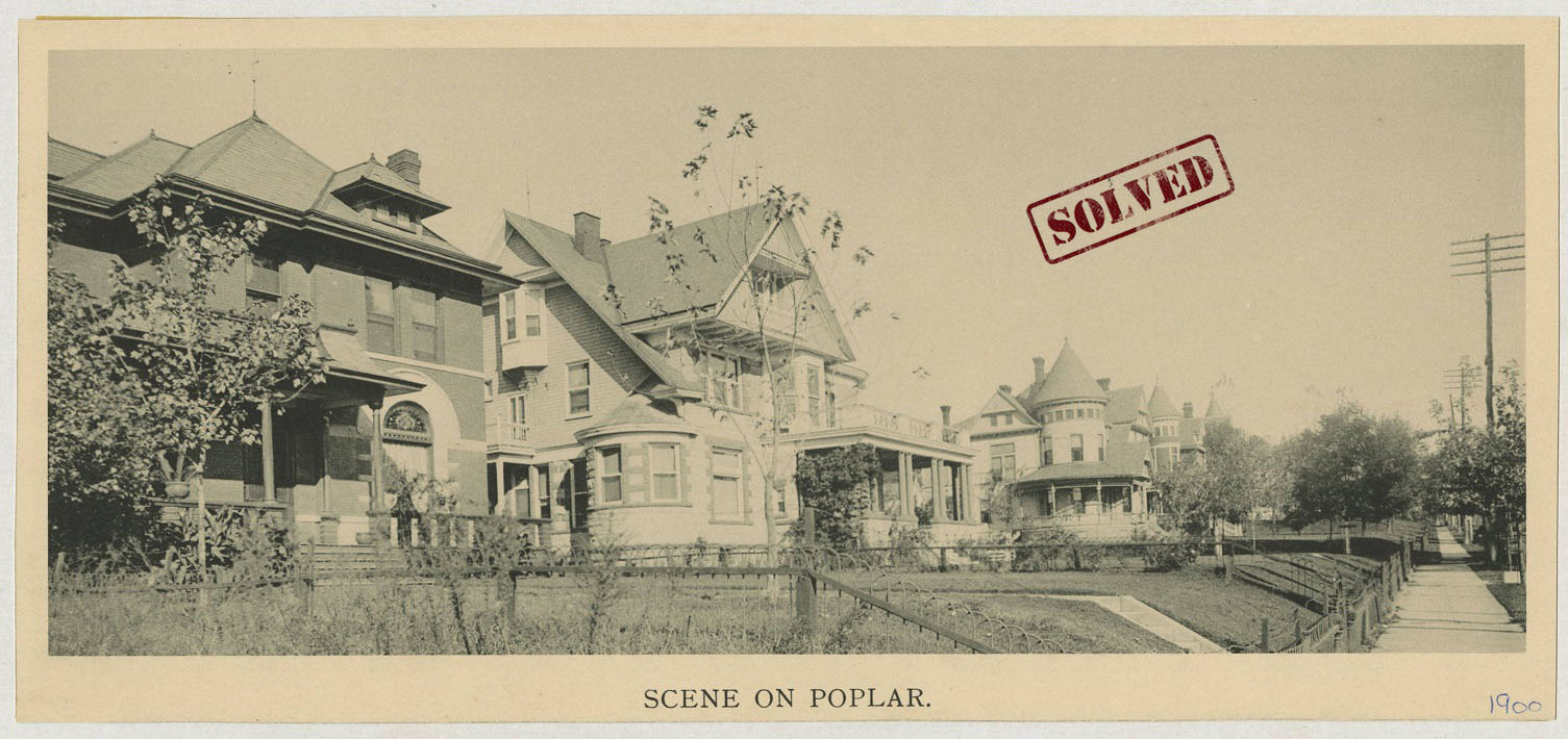
This black and white postcard shows homes along Poplar Avenue at the turn of the twentieth century. The caption on bottom of postcard reads, “Scene on Poplar. 1900.” Poplar Avenue has changed dramatically over the course of the previous century. Can you determine what block of Poplar Avenue is shown here?
solved!!
Phoebe Moore cracked the case on this mystery using a few different sources. She pointed out that the Sanborn Fire Insurance Map shows the turreted house at the northeast corner of Cochran and Poplar – the address is 1048 Poplar. The footprint and construction materials of that house and the other houses visible in this photo match up. More evidence confirming this location can be found on the second copy of this photograph, which includes handwritten details! The notes on Street0830 indicate that we’re looking toward North Cochran to Waldran, placing our photographer near the corner of Poplar and Decatur Street.
[expand title=”Click here to share additional details!”] — [/expand]
6/15/2020:
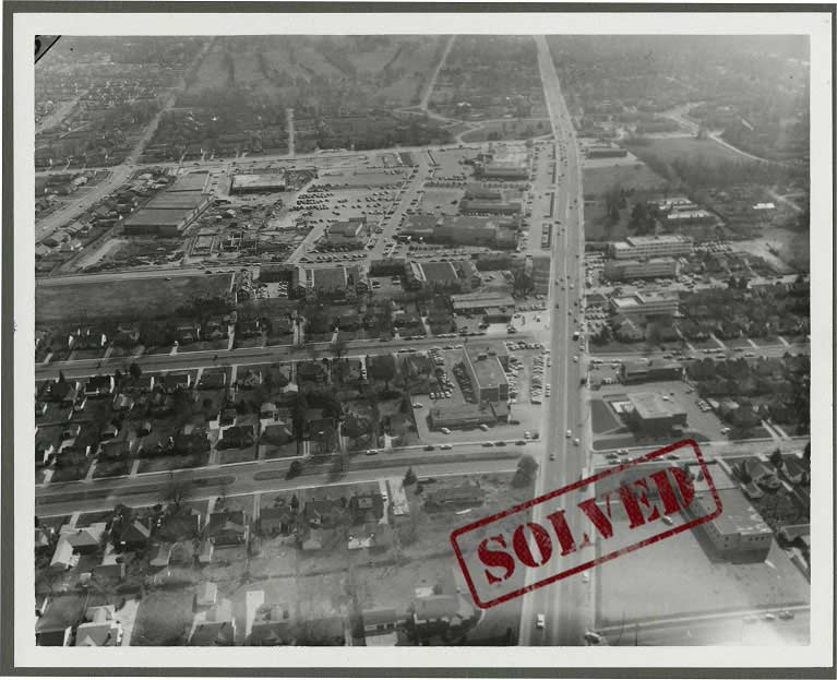
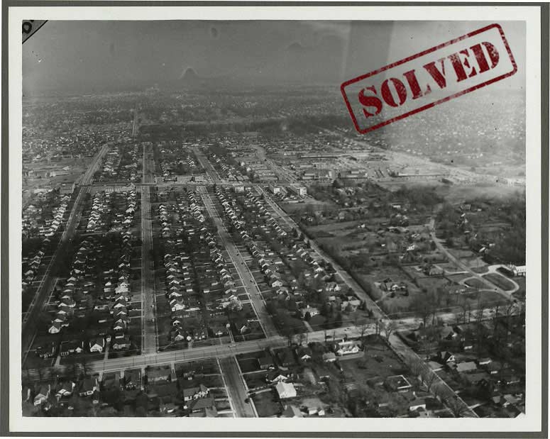
The Memphis Streetscapes Collection contains a number of aerial photographs taken high above Memphis streets. The caption on this photograph simply states, “3-18-58 Poplar.” Without the ability to read signs on streets and businesses, it can be difficult to determine where the aircraft was located when this image was created. Can you help provide coordinates for this image?
solved!!
We received a few submissions for this one, and everyone was correct! An anonymous detective submitted these coordinates: 35.1300283, -89.9531981, but everyone agreed the plane was likely over East High School. Glenn Bandy pointed out that in the background (at the top left) you can see Galloway Golf Course, and next to that, Poplar Plaza, which appears to be under construction. The first median-lined road on the left is Century St. and the second (going East) is Reese St. Thanks to all the eagle-eyed sleuths who recognized buildings and streets in the photograph!
[expand title=”Click here to share additional details!”] — [/expand]
This photograph was taken on the same day as the one above. The caption on the back also states, “3-18-1958 Poplar.” Can you determine the location depicted in the image?
solved!!
This mystery was solved shortly after the one above. It’s likely that the plane simply moved further south, and the photographer pointed the camera north. We can see East High School on the left side of the image, and Poplar Plaza is visible over on the right. That would put the aircraft just south of Central Avenue, with the camera facing toward Poplar: 35.122571, -89.951813.
[expand title=”Click here to share additional details!”] — [/expand]
6/08/2020:
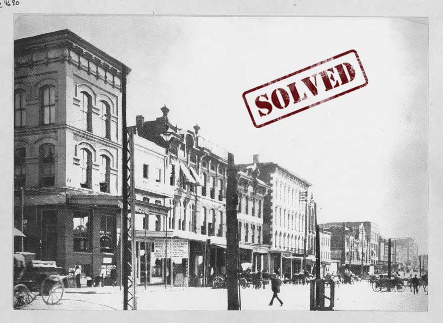
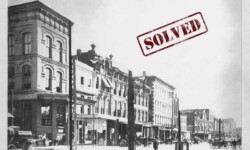
This photograph of Front Street, looking southwards, was taken in 1907. Pedestrians and horse-drawn carriages are outside the storefronts that line the busy street. It appears the photographer is standing near the intersection of Front and a street that can be seen heading east, on the left side of the image. Can you locate this block of Front Street?
SOLVED!!
This mystery was initially solved by Jan Scandlin, but also confirmed by Phoebe Moore and a second anonymous sleuth. Jan took us on a thorough and entertaining journey into how she solved this mystery. She first noticed that there was a clearer version of this photograph in DIG Memphis, as part of the Nadia Price Photography Collection: Digital ID NPP0551. In that image, we can see a sign on top of one of the buildings that reads “R G Craig”. She noted the details on the surrounding buildings, but nothing pinpointed exactly what addresses were captured in the photograph. Jan then searched the Commercial Appeal and found multiple results for R.G. Craig, the person, and also the business. Turns out, R.G. Craig had multiple businesses/ buildings. In the early 1900s, R.G. Craig & Co. did business at 296-298 Front Street and 10-12 S. Front St., and in 1901 had purchased two lots on the east side of Front St., north of the alley just north of Adams St. So, how to determine which building was depicted in the photograph?
She checked the 1907 City Directory, which confirmed there was a R.G. Craig building at 10-12 S. Front St., and so, armed with that information she went back into DIG Memphis to look through additional photographs. The first one she looked at was a 1901 image of Front Street: Street0109. The buildings on the left in the distance looked familiar – “tall building on a corner, then a short building with a plain roof-line, then a building with decorations at either end, then one or more buildings, then a wide light-colored building.” The description on the digital item, “Front Street nearly 40 years ago looked like this. The Federal Building as it was then, in its present location, is seen at the right and just beyond is the tower on Cossitt Library…” would be consistent with the 10-12 South Front Street location!
The next item she examined was one of our Memphis Then & Now photographs: Madison St. from the Post Office, also seen in Digital ID Street1088. The upper floor windows of the building on the southeast corner look like the upper floor windows of the tall narrow corner building in our mystery image! All of this confirms the photographer of our mystery image was likely standing at the western end of Madison Avenue at Front Street: 35.145605, -90.054111.
Phoebe Moore contributed one additional important piece of data: our photograph appears in a digitized copy of a 1904 souvenir book published by McCrorey’s Five and Dime store (found on Historic Memphis), meaning this photograph was likely taken in 1904 instead of 1907.
[expand title=”Click here to share additional details!”] — [/expand]
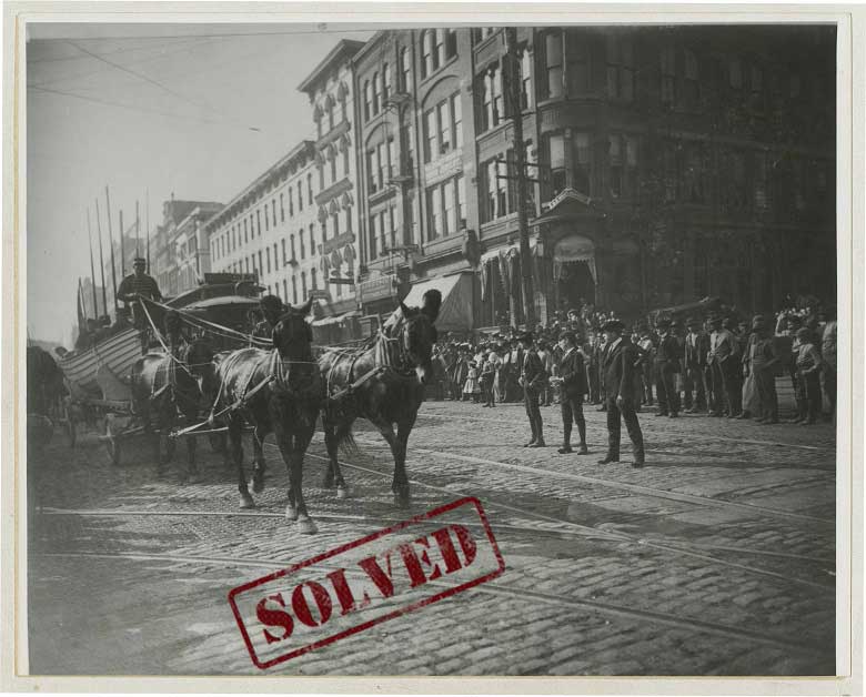
This old photograph shows a horse-drawn carriage pulling a boat. A crowd of onlookers can be see lining the cobblestone street, watching what was a likely a parade. The description on the digital item identifies this as Main Street, although it’s not clear if the physical photograph was labeled that way. Can you confirm this is Main Street and pinpoint the exact location?
SOLVED!!
Jan Scandlin and Jennifer Dorris both solved this mystery by examining the signs on the corner building in the above image. Under the second floor window is a small sign that reads ‘G. E. West Dentist’, and to the right of the doorway is a window that says ‘Bank’. Beginning in the 1903, the City Directory has a listing for “G Edgar West Dentist at 337 Main (Over Security Bank)”. As Jan Scandlin points out, based on a Commercial Appeal article from September 6, 1962 (p.6), “338 Main was a Union Avenue corner under the old street numbering system…”. Jennifer Dorris adds, “in 1905 the buildings were renumbered, and the address became 77 S. Main.”
Dr. West’s office was only at this location from 1903 to 1905. From 1906 to 1910 Dr. West’s office was in the D. T. Porter Building, the Randolph Building, and the Tennessee Trust Building. Jan Scandlin noted that there is another copy of the photo in DIG Memphis, and the photograph appears in a Commercial Appeal article from May 27, 1973 (p. 99) that discusses the photographer of this image and others, Abe Frank. Mr. Frank obtained his camera in 1902 and took many photographs in the Fall of that year, many of which can be seen in DIG as part of the Coppock Collection.
In the CA article, the above image is described as depicting a “Coast Guard boat”. Scandlin hypothesized that this parade could be part of the “Grand Street Cavalcade” through town that took part as part of “Buffalo Bill’s Great Wild West”. A Commercial Appeal article described this demonstration as including “…the saviors of the wrecked – the United States lifesaving crew with government outfit complete, showing the use of the breeches buoy.” (November 5, 1902, p.7) Lifesaving boats from this period did look similar to the one in the our photograph, so it is possible. If you can find more information about this parade, let us know below!
Based on the information in the city directory, the photographer was standing on the northeast corner of Main Street and Union Avenue, near the coordinates: 35.14323, -90.053545.
[expand title=”Click here to share additional details!”] — [/expand]

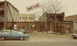
The above drawing appeared in the Commercial Appeal along with this caption, “This was a busy corner 35 years ago. The old Southern Railroad depot is across Lauderdale to the right. It was once the passenger station of the Memphis & Charleston. Lauderdale and Piomingo Avenue is at the transition point. Another old part of town will soon be swallowed by the new as a “for rent” sign hands [sic] on the Lehman store.” What were the coordinates for this spot?
SOLVED!!
Jan Scandlin submitted the answer to this mystery. She began by researching the intersection of Piomingo and Lauderdale St., and found a Crème de Memph article titled, “The Widening of Jefferson Ave.” that was particularly helpful. The article contains many images from DIG Memphis showing the general area of the M. & C. R. R. Depot. From there, she consulted multiple maps from our Map and Poster Collection. The 1870 Bird’s Eye View map has a really nice drawing of the area, and the 1951 map labels it “Southern Yards.”
The 1870 map indicates that at that time the street was named Charleston Avenue. According to the City Directories, beginning in 1891, there is a listing for Felix Lehman at 68 Charleston Avenue. This is further confirmed by an article that ran on November 18, 1903, in the Commercial Appeal , detailing a burglary where “burglars entered the store of Felix Lehman, 68 Charleston Avenue, last night between 11 o’clock and midnight, and took two hats and two shirts from the show window”.
By comparing the older maps to maps from today, Jan Scandlin was able to determine the location to be in the vicinity of the present-day Paul Borda Towers, east of Danny Thomas Blvd., with the coordinates roughly around: 35.143345, -90.042998.
[expand title=”Click here to share additional details!”] — [/expand]
6/1/2020:
This week we’re highlighting something a little different: architectural details! Our Memphis Streetscapes Collection contains a few close-up photographs depicting the details on buildings. This presents a unique challenge because there is no background information visible that would provide clues for what this is and where it is located. Can you help locate the buildings in these images?
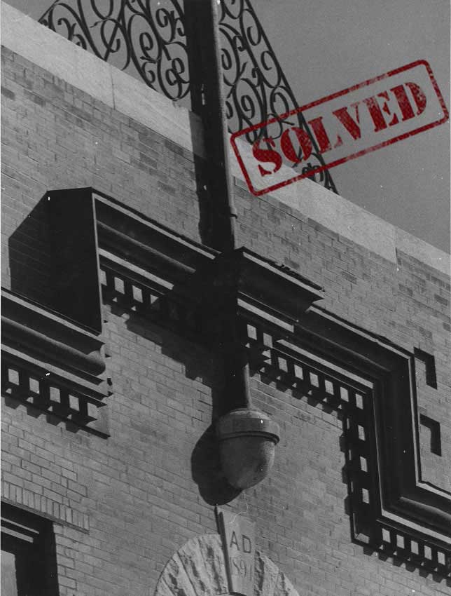
This image is close up of a design built into a building. The keystone reads: AD 1894 or possibly 1891. Note on the back reads: “Duplicate print from the Urban Renewal Files in the Archives”. You can see this same building in a second image here: Street0208. Can you provide the name and/or location of this building?
SOLVED!!
The solution to this mystery first came to us via our Instagram page. Julie McCullough thought the details looked familiar and searched her own photographs, quickly finding a match! The building is located at 162 Beale Street, and is now home to King’s Palace Cafe and The Absinthe Room.

[expand title=”Click here to share additional details!”] — [/expand]
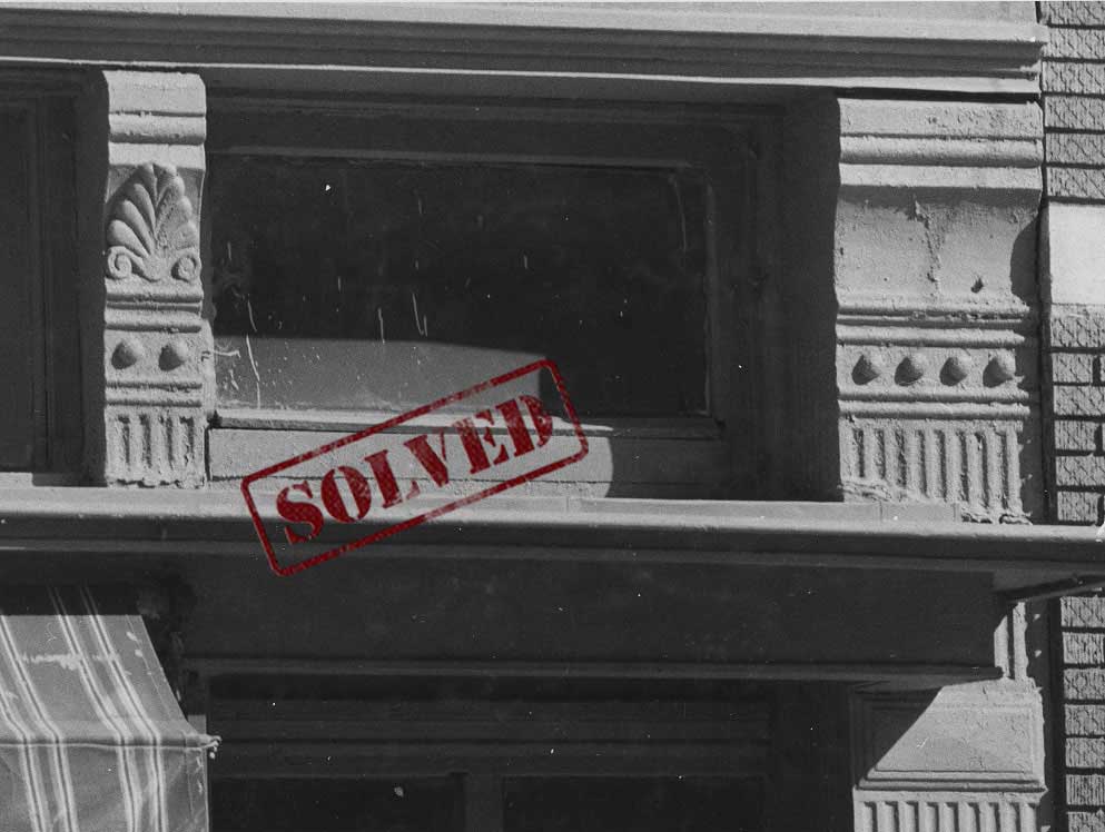
This photograph captures the elaborate details employed in a building. Note the design in the brick to the right. The note on the back reads: “Duplicate print from the Urban Renewal Files in the Archives”. Do you know what building is seen here?
SOLVED!!
We received the answer to this mystery through the web form, from someone with great attention to detail. Honing in on the brick work, that submission stated, ” Looks like the brick that’s on the building directly next to and apart of Kings Palace Cafe.” Sure enough, if we zoom in on the building at 166 Beale Street, the bricks do match those seen on the right side of the photograph. It appears that the building details, as seen in the older image, are currently obscured by an awning over 162 Beale Street, but you can still see part of the building’s features along the sides of the door here.
[expand title=”Click here to share additional details!”] — [/expand]
5/18/2020:
For this week’s mysteries we’re focusing on a few photographs depicting different areas of Lauderdale Street. Lauderdale and its neighboring streets have undergone many changes over the years, especially with the development of Danny Thomas Boulevard. Can you help us determine the coordinates of the images below?

The current descriptive record on our first image indicates this to be “Lauderdale Street looking towards Madison Avenue in 1938.” It’s not clear what direction photographer was facing. Using the details seen in the photograph, can you confirm that the photographer was indeed facing Madison Avenue? Were they facing north or south? If you can, share the latitude/longitude coordinates with us, which can be determined by using Google Maps.
SOLVED!!
The solution to this mystery was a multi-step process. Phoebe Moore found an address for Electric Retread Services (seen on the right side of the photograph) in the City Directory: 91 North Lauderdale. The Directory indicates that the address numbers climb as one moves north on Lauderdale. St. John Baptist Church is listed in the directory as being located at 59 North Lauderdale, and in fact, we can see a bit of the church steeple in the background behind Electric Retread Services. This 1925 map shows St. John Baptist Church on N. Lauderdale between Court Avenue and Jefferson Avenue, and the City Directory indicates that Electric Retread Services was located just south of the intersection with Adams Ave., putting our photographer at about 35.146232, -90.044342.
[expand title=”Click here to share additional details!”] — [/expand]
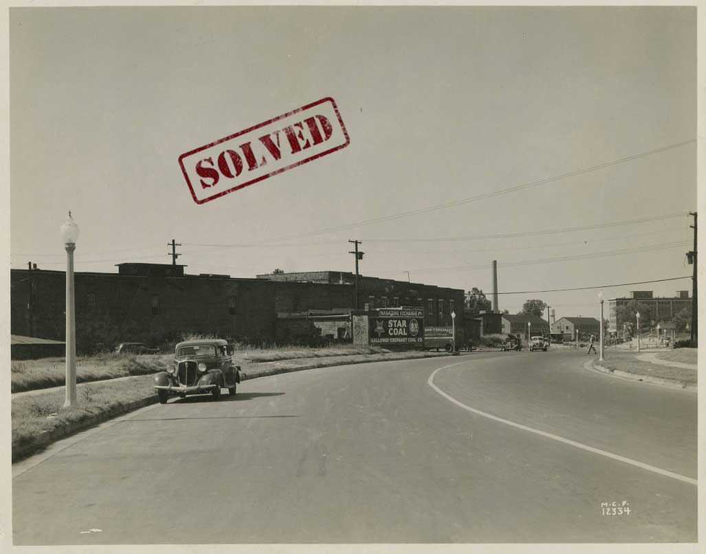
This photograph shows a sign for Star Coal along “the extension of Lauderdale Street”. We can see some traffic, including what appears to be a transfer/storage truck in the distance. The image below depicts this same area from a different vantage point. Can you determine the geographic coordinates for the spot where this photographer was standing?
SOLVED!!
We received a the answer to this mystery from Glenn Bandy, who focused on the painted signs seen on the buildings at the left. According to the 1938 Memphis Directory, the location for Armstrong Transfer is 280-282 Poplar. You can see the painted sign on the top of the far brick building on the left. The Magazine Exchange was at 295 Poplar, which is the building across the street displaying its sign above the Star Coal sign. This would put our photographer between Poplar Avenue and Washington Avenue, facing north, roughly 35.147878, -90.044403.
[expand title=”Click here to share additional details!”] — [/expand]
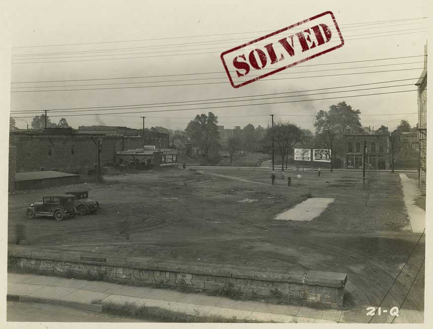
The image here appears to be showing the same area as the photograph above. We can see the same Star Coal sign in the background. This photo was taken from an elevated space one block over and shows people, perhaps children, playing in an empty lot. Can you figure out what area we’re looking at here?
SOLVED!!
This mystery was also solved by Glenn Bandy, who pointed out that this image is near the same spot as the photograph above, but this photograph was taken was before Lauderdale Extended cut through the lot. We can see the signs on the same Magazine Exchange building, making the street in the background Poplar Avenue. The Gayoso Bayou can also be seen in the background on the northern side of Poplar Avenue, and the old Tech High School is just barely captured on the right, at the very edge of the photograph. This puts the photographer on the 300 block of Washington Avenue, at about 35.147330, -90.044363.
[expand title=”Click here to share additional details!”] — [/expand]
5/11/2020:
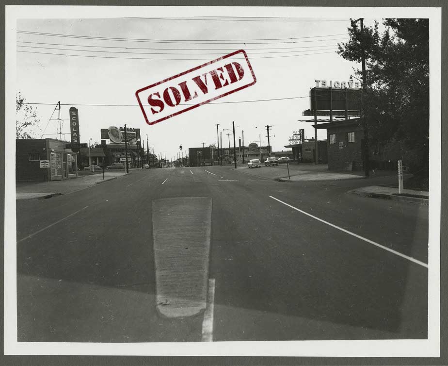
This week’s mysteries are two images with businesses visible in the distance. The first photograph shows stores and businesses along North Parkway. The caption on back of photo indicates it was taken on November 25, 1956, but where? Can you locate any of the businesses and pinpoint where the photographer snapped this shot in 1956?
SOLVED!!
The solution to this mystery was found by locating Scola’s Market, which can be seen on the left side of the image. We received a couple of submissions indicating that Scola’s Market was located on the southeast corner of North Parkway and Thomas St./Danny Thomas Blvd. The Commercial Appeal Archive shows many ads for Scola’s Market at 653 North Pkwy. You can see the Peyton St. sign on the right side of the photograph, and although Peyton no longer reaches North Parkway, Peyton Circle still exits just north of the Parkway. The photographer was facing west around these coordinates: 35.155565, -90.036458.
[expand title=”Click here to share additional details!”] — [/expand]
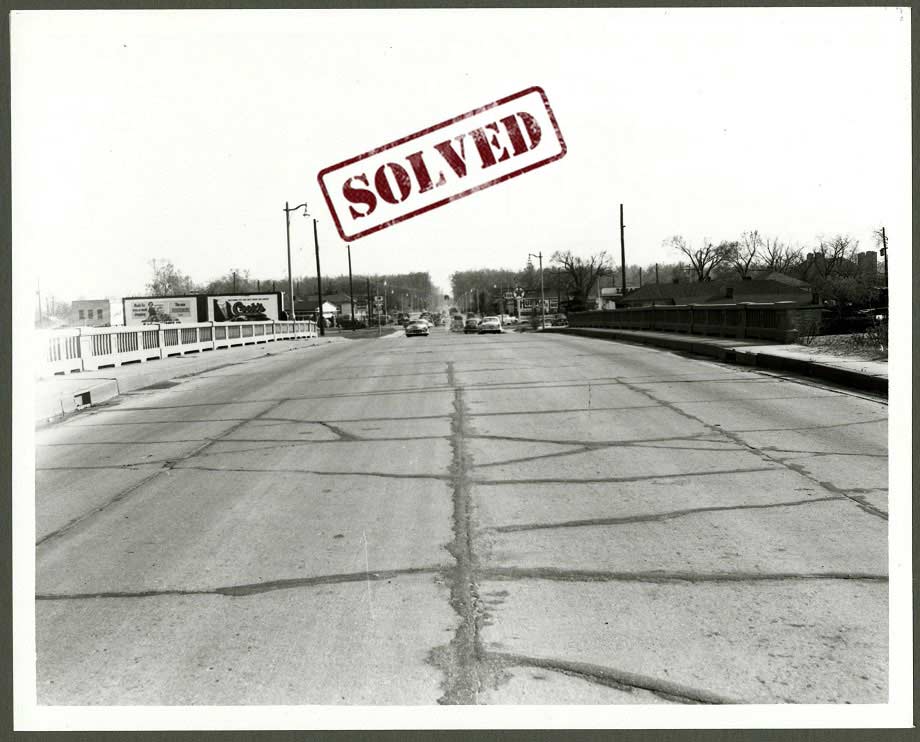
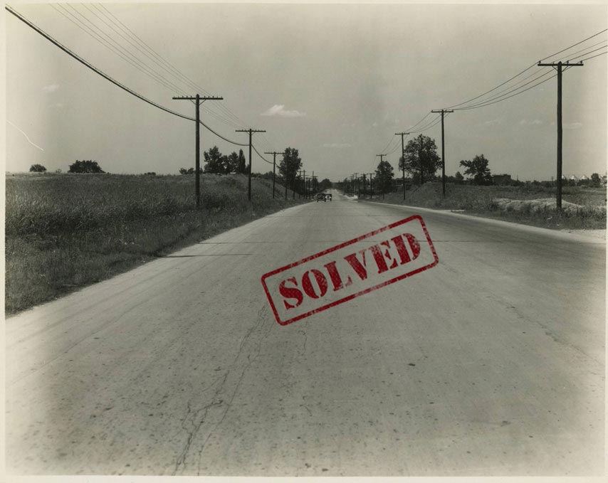
The second image shows patched pavement on South Third Street in April 1951. A bridge with concrete railings is visible. The background shows traffic on South Third, a Texaco gas station, and two billboards. Can you determine the location of this bridge on South Third Street?
SOLVED!!
We received a few submissions answering this mystery, all indicating that we’re looking at South Third near South Parkway. One answer specified that this “is a section of South Third between South Parkway East to the south and McLemore Avenue to the north. The bridge and railings were redone a few years ago.”
Another detective pointed out that a building seen in Digital ID Street1012 along South Parkway can also be seen in the distance on the left side of the image above. When zooming in on that building on the left, you can make out part of the name on the building: “….witz”. According to a July 6, 1950 article in the Commercial Appeal archive, “Mrs. Louis Liebowitz and her son, Richard, of New York, are guests of her sister and brother-in-law, Mr. and Mrs. Milton Moskowitz of 235 South Parkway East.” That address matches the building in the image, providing further confirmation that we’re facing South Parkway East.
Further research using the Commercial Appeal archive, revealed a listing for a Texaco Service Station at 1447 South Third, and a Texaco sign can be seen in the image above, at that address. All of this research confirms that the photographer was likely set up around the coordinates: 35.109840, -90.055302.
[expand title=”Click here to share additional details!”] — [/expand]
5/4/2020:
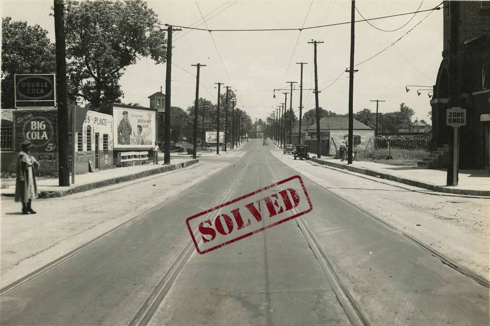
This photograph shows paving work being done on Jackson Avenue in May of 1938. The woman on the left appears to be standing at a cross street, but there are no visible signs indicating what street is crossing Jackson Avenue here. Can you determine which area of Jackson Avenue is seen in this photograph?
solved!!
We received many suggestions, and this solution required a multi-step approach. It all starts with the business sign that can be seen under the ‘Double Cola’ advertisement on the left: Irene’s Place. The Commercial Appeal Archive has a few articles that mention Irene’s Place, owned by Harvey Graham, located at 332 Jackson Avenue. The 1938 Polk City Directory confirms a ‘Graham Harvey restr’ at 332, between Concord Ave. and N. Seventh St., just west of the where the L&N Railroad crosses Jackson.
This 1925 map shows this particular area of Jackson Avenue and indicates that St. Paul Baptist Church is on the SE corner of Jackson and Concord. Our photo does indeed show a church on that corner, across from Irene’s Place. So what does that location look like today? The area has been completely reformed as part of the St. Jude Children’s Research Hospital campus, but you can still see the basic structure of the roads on Google Maps.
Concord Avenue is now Shadyac Avenue. The likely coordinates for this photograph are 35.154274, -90.041788. Thanks to everyone who submitted suggestions!
[expand title=”Click here to share additional details!”] — [/expand]
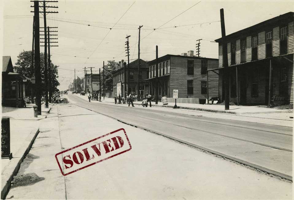
Here’s another Jackson Avenue mystery from May 1938. This
photo shows surfacing work being done as part of a Works Progress Administration project. Without many notable signs, it is difficult to determine where this photographer was standing. Can you locate this stretch of Jackson Avenue?
solved!!
This mystery was solved by Phoebe Moore! She first consulted the Commercial Appeal Archive and found articles from May of 1938 that discuss the WPA project along Jackson Avenue. A May 22nd article states, “Jackson Avenue paving from Main to Manassas will be finished by June 1.” Another from May 25th describes that “drainage on Jackson Avenue is being reconstructed to conform with new pavement.” This description does appear to match the work being done in the image, and limits our search from Main to Manassas.
Next, she took a look at the 1938 Aerial, where she noticed the buildings in the photograph look like the ones seen on Jackson between Lauderdale and 3rd, specifically, the building on the northwest corner of Jackson and Third seems to match the building facing the street (in the background, on the right side of the photograph). The apartments/duplexes in the foreground also match the buildings seen just east of Third Street on the aerial map, and we see a service station across the street, which matches the Shell sign seen in the image. Further, the 1938 Polk City Directory confirms there was a filling station at 181 Jackson Avenue, just east of Third Street.
All of this evidence suggests the photographer was standing near the middle of the block between Third Street and what was then Commerce Avenue, facing west: 35.153183, -90.045722.
[expand title=”Click here to share additional details!”] — [/expand]
4/27/2020:
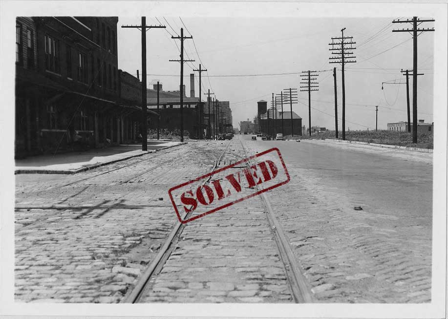
This 1938 photograph shows the trolley railways running along North Front Street. A man sits under an awning (left), and the Industrial Supplies Inc. building is in the background (right). The photographer is standing near a particular cross street (on the left), but which one?
SOLVED!!
This mystery took a long time to definitively solve! We received many submissions, with most people suggesting spots in the general area of Front Street, north of Poplar Avenue. Narrowing it down to which cross street took some work. Many detectives, like Devin Greaney, focused on the Hotel Claridge sign, seen in the distance on the left. This building, now known as the Claridge House Condominiums, stands at the corner of Main Street and Adams Avenue.
Another person pointed out that we can see the northern side of Ellis Auditorium in the image. Crème de Memph’s post on Ellis Auditorium has some good images showing that triangle roof that we can see just under the Hotel Claridge sign in our photograph. This puts the photographer not only north of Adams, but also north of Exchange Avenue since Ellis Auditorium spans the block from Poplar Avenue to Exchange. So, we’re looking for a spot at least a block or more north of Exchange Avenue.
Phoebe Moore finally cracked the case using the 1938 Aerial Imagery provided by Shelby County. As she pointed out, the number of buildings in the first block on the left [in our photograph] and the telephone pole locations seem to match what the aerial map shows for the block between Winchester Avenue and Commerce Avenue. Also, the map appears to show an empty lot at the southeast corner of Front and Winchester, and in fact, our photograph shows a lot with grass and weeds in that same spot! This would put our photographer just north of the intersection of Front Street and Commerce Avenue: 35.154049, -90.050733.
[expand title=”Click here to share additional details!”] — [/expand]
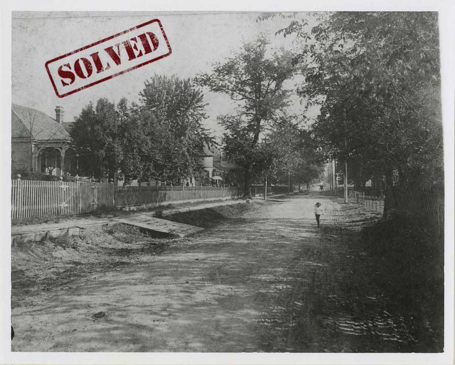
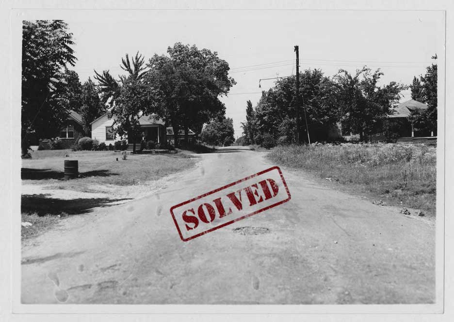
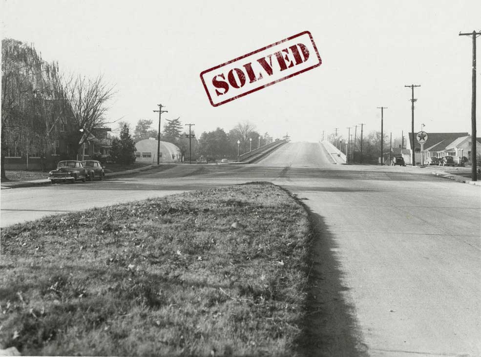
This undated photograph shows a child on an unpaved McLean Blvd. Unlike other images in our Memphis Streetscapes Collection, this item does not have geographic data in its record. Do you recognize any of the structures shown here? Can you determine which stretch of McLean is captured in this photograph?
SOLVED!!
This mystery was solved when a sleuth submitted the coordinates for another photograph depicting the same block of McLean Avenue. That photo, Digital ID Street0474, was taken some years after the one above, but it also shows the home in the background with the turret. That house is still standing!
Using the Street View feature of Google Maps, we can confirm that it is the house seen here. The photographer was likely standing somewhere near the coordinates of 35.132819, -90.000437.
[expand title=”Click here to share additional details!”] — [/expand]
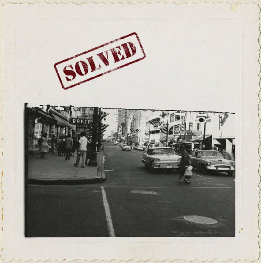
The caption on back of photo reads, “Oct. 1958…From the Civic Center Advisory Committee.” Although we can’t see many of the signs or tops of buildings, we can see pedestrians walking and cars driving along Main Street. The photographer is standing on street corner or in a crosswalk, but where? Can you determine which corner of Main Street is seen here?
SOLVED!!
Many virtual detectives cracked this case, everyone supplying a different piece of the puzzle. Most focused on Baker’s Shoes, which can be seen on the right side of the image. According to the 1943 City Directory, Baker’s Shoes was once located at 17 N. Main Street, but by 1958, Baker’s Shoes was located at 105 S. Main, as is evident in multiple advertisements and articles in the Commercial Appeal.
105 S. Main would place our photographer at the southwestern corner of Gayoso Avenue and Main Street. A few other detectives pointed to the businesses across the street: Stein’s Furs, which was located at 96 S. Main and Paul’s Shoes, which was at 104 S. Main. These businesses confirm we’re at the right spot, and a few people even submitted the correct coordinates: 35.1419964,-90.0542208. Google Street View provides added confirmation. We can still see the old Baker’s Shoes tile at the building entrance!
As an extra bonus, two people supplied details about the vehicles in the photograph. The car on the right is a 1955 Studebaker Speedster, the only year they were made. The car next to it is a then, brand new 1958 Oldsmobile Super 88. Thanks to everyone for the detailed information!
[expand title=”Click here to share additional details!”] — [/expand]
4/20/2020:

This photograph from 1940 shows workers placing trolley wire along Mississippi Boulevard. The caption on back of the physical photograph reads, “Reeling off trolley wire-11-4-1940 on Mississippi Blvd.” Can you determine where these men were working back in 1940? If so, please share the cross street or latitude/longitude information.
SOLVED!!
We received several solutions. One involved using the online City Directories (in our list of resources at the top of this page) to locate Gas Stations on Mississippi Boulevard in 1940 (see the gas station in the background?). Then, using Google maps, our detective was able to search the gas station’s address and activate the Street View option to see the current street. They then noticed the building on the right was still standing!
Another solution involved searching the Commercial Appeal archives (also in our list of resources at the top of this page), where our second detective found an article from March 1940, detailing the location of the trolley improvements. They then also used Google maps and saw the same building on the right.
Over on Instagram, Josh Whitehead (@joshdwhitehead) suspected it was a church a few blocks down at 974 Mississippi Blvd., but then realized that church didn’t have the little side window that appears in the older image. Using Google Maps to progress down the street, he then realized an old church at 878 Mississippi Blvd. did match the details of the building in the photo, specifically, the little side window!
You can see the comparison below.

[expand title=”Click here to share additional details!”] — [/expand]
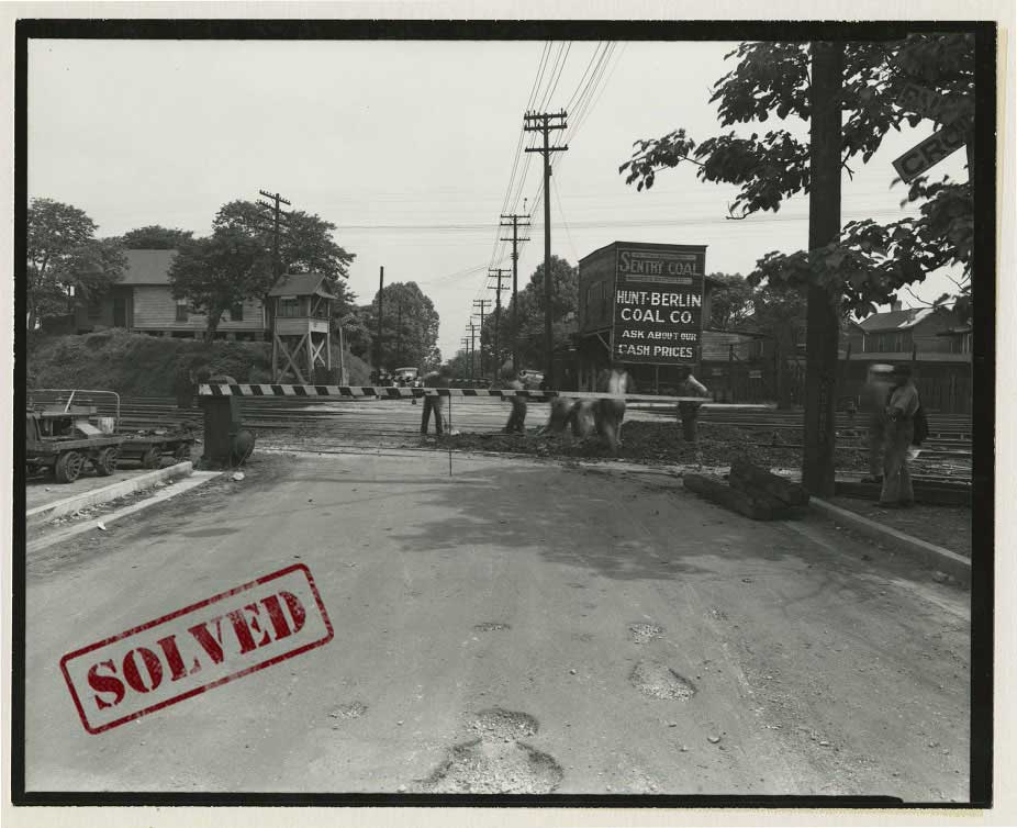
The men pictured here are working on the L & N Railroad tracks. The caption on back of photograph reads, “5-27-1940, Orleans Street Crossing at L & N tracks.” Because streets and railways have changed over time, it is not immediately clear where this photograph was taken. Can you locate this spot by providing an address or latitude/longitude data?
SOLVED!!
We received the solution to this mystery in the form of the coordinates: 35°07’31.0″N 90°02’25.2″W. According to the 1940 City Directory, Hunt-Berlin Coal Co. Yard was located on S. Orleans, just north of the railroad crossing. The directory also indicates that E. Cherry ended at this spot, which is evident by the post marked “Cherry” on the right side of the image. Maps from this time indicate that these are the N.C. & St. L. tracks; however, they were used by the L&N Railroad.
[expand title=”Click here to share additional details!”] — [/expand]
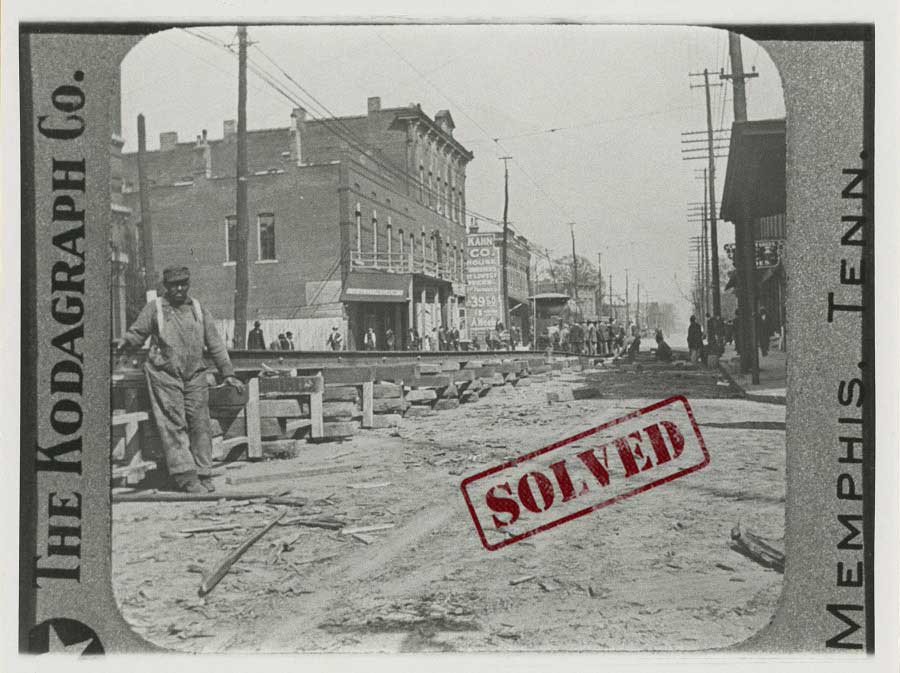
This old image of Poplar Avenue shows men working on a construction project along a dirt-covered road. The caption on sides of photo reads, “The Kodagraph Co. Memphis, Tenn.” The caption on back of photo simple indicates, “Poplar Ave.” But where? Based on some of the signs in the background, can you determine where this is and when this photo was taken?
SOLVED!!
The solution to this mystery came to us via our Instagram page. Our virtual detective honed in on the Kahn Co. sign that is partially visible on one of the buildings in the background, and he noticed that we had another photograph of Kahn Furniture Co. in our archive. The image found in Digital ID Street0815 describes a note on the back of the photograph that reads, “Leo Kahn & Co. 352-354 Poplar Ave. Leo Kahn manager (1912 directory)”.
That location checks out! 352 Poplar Avenue falls between Lauderdale St. and the intersection of Carroll Ave./High St., which is confirmed in the 1912 City Directory. Further confirmation can be found in the depiction of the slightly raised tracks. Around the spot where Poplar crosses the Gayoso Bayou, the streetcar tracks become raised. You can see this in multiple images in DIG Memphis, and as seen in this map from 1925, the Gayoso Bayou crossing was just east of Fourth Street.
This puts our photographer right around the modern-day intersection of Poplar and Danny Thomas Blvd.: 35.148262, -90.043749.
[expand title=”Click here to share additional details!”] — [/expand]
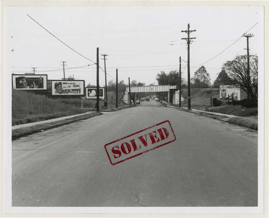
4/13/2020:
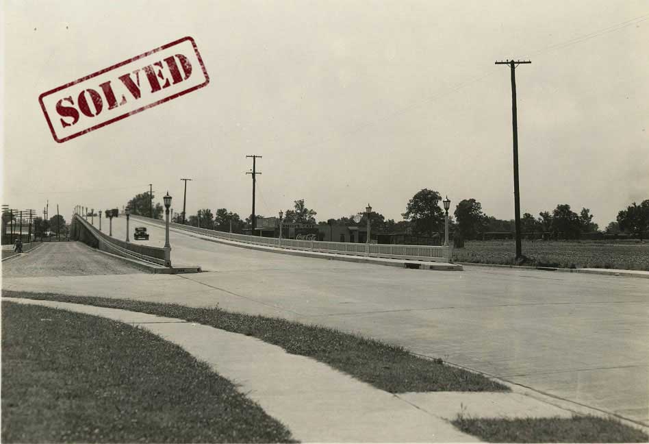
The above photograph from 1938 shows the Jackson Avenue Viaduct. Unlike most of the images in our Streetscapes Collection, this one does not have specific geographic data attached to it. Can you determine the exact location this photographer was standing back in 1938? If you can, share the cross street or Latitude/Longitude information, which can be found by using Google Maps.
SOLVED!!
This solution was a joint effort! We received a couple of answers pointing to different sides of the Jackson Avenue Viaduct. To determine which side the photographer was standing, we must locate Schmidt’s Café. The café seen in the distance is not listed by name in the 1938 City Directory. The only restaurant that is listed in the area of the viaduct is ‘Pryor Wm D restr’ at 2876 Jackson Avenue, which is a possibility! When searching ‘2876 Jackson’ in the Commercial Appeal, we found a small social announcement stating, “Winnifred Smith of Paducah, Ky.is visiting Mr. And Mrs. L.C. Schmidt at their home at 2876 Jackson.” – therefore tying the Schmidts to the restaurant near the eastern side of the viaduct!
The photographer appears to be standing on the southeastern side of the viaduct, facing west, near these coordinates: 35.159800, -89.963566.
[expand title=”Click here to share additional details!”] — [/expand]
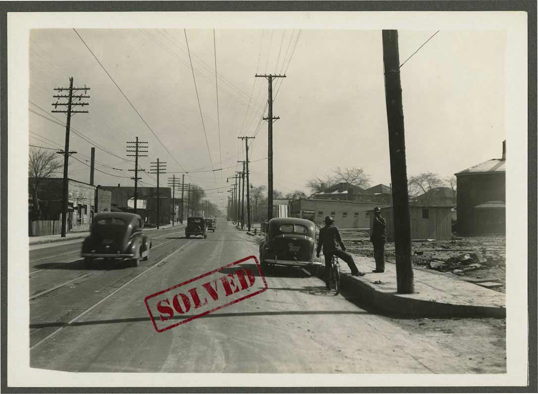
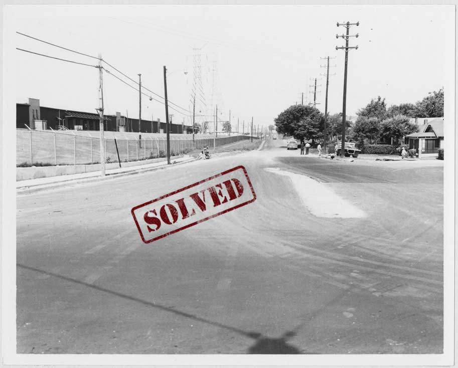
This photograph captures a pedestrian talking to a man on a bicycle next at the intersection of Lamar Avenue and Woodward Street. Because this area has undergone dramatic changes over the years, we currently do not have Latitude/Longitude data for this spot. We’re also unsure what year the photographer snapped this photo. Can you determine the exact location and time period captured here? If you can, please share!
SOLVED!!
This mystery was solved by examining old maps of Memphis, specifically the Map of the city of Memphis & vicinity (1925) as found in the Tennessee Virtual Archive. On this map, we see Lamar and Woodward prior to the development of the interstate. Woodward Street now ends before reaching Lamar Avenue, but if we follow the old map, it places our photographer on Lamar near the current on-ramp for I-240 South: 35.130662, -90.024423.
Determining the date of the image is a little trickier. By zooming in on the car and its license plate, a detective noticed that this vehicle is similar to the one seen on the right side of this image from 1938. The license plate also seems to match the one from 1938, as seen on this list. While we’re not 100% certain, it does appear that this photograph was likely taken sometime around the year 1938.
[expand title=”Click here to share additional details!”] — [/expand]
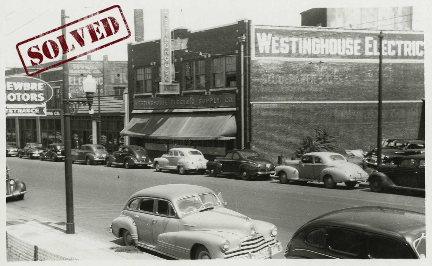
The image above shows Madison Avenue in 1950. A couple of business signs are visible, including Westinghouse Electric Supply Co., but none of the street addresses can be seen. Where was the Westinghouse Electric Supply Co.? Can you locate this block along Madison Avenue?
SOLVED!!
We received many submissions for this mystery. Thanks to everyone who sent in information! The solution was a joint effort. According to the 1943 City Directory Westinghouse Electric Supply Company was located at 366 Madison Avenue, just west of the intersection with Wellington. On the left side of the image, we see a partial sign for Dewbre Motors. Advertisements for Dewbre Motors first appear in the Commercial Appeal in October 1947 and list the company at 365 Madison Avenue. This confirms our location.
By April of 1949, Dewbre Motors moves to 349 Monroe Avenue (per Commercial Appeal advertising), which means the 1950 date can’t be correct. Further, ads in the Commercial Appeal in August of 1948 list 366 Madison as being for sale, and on September 12, 1948, Westinghouse announces they are in their new location at 845 N. Main Street. By January 2, 1949, Dunlop Tire has moved into the old Westinghouse location, which is confirmed by this image: Street0494.
The photograph above must have been taken sometime between 1947 and mid-1948. The photographer was standing near the southwest corner of Madison and Wellington. Danny Thomas Blvd. now runs roughly the same route as Wellington St., although the street has been significantly widened. The likely coordinates for this location are: 35.142901, -90.044300.
[expand title=”Click here to share additional details!”] — [/expand]
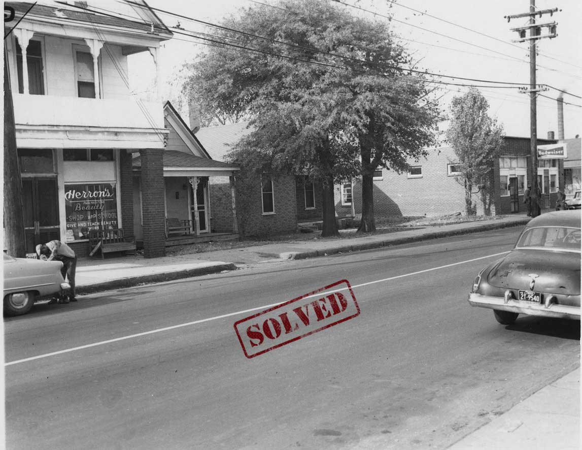
This undated photo of Florida street shows Herron’s Beauty Shop and School on the left side of the road, but where was Herron’s Beauty Shop located? Do you know which block of Florida Street is depicted in this photo?
SOLVED!
This mystery was solved over on our Instagram page! Julie McCullough (@thisplaceinhistory) pointed to the image found in Digital ID Street0086 and noted that the building that housed Herron’s Beauty Shop can be seen on the left side of that photo. As indicated by its title “Florida Street and Olive Avenue (2)”, the photograph seen in Digital ID Street0086 was taken just south of the intersection of Florida St. and Olive Ave., which would place Herron’s Beauty Shop in the 1300 block of Florida Avenue.
By examining the license plate seen on the right side of the image and consulting a list of Vehicle registration plates of Tennessee, we can determine that the plate on the car is likely from 1959. The photographer was standing near the coordinates: 35.110727, -90.062292. The western side of this block has been completely transformed, but the eastern side still has several buildings that are seen in Street0086.
[expand title=”Click here to share additional details!”] — [/expand]
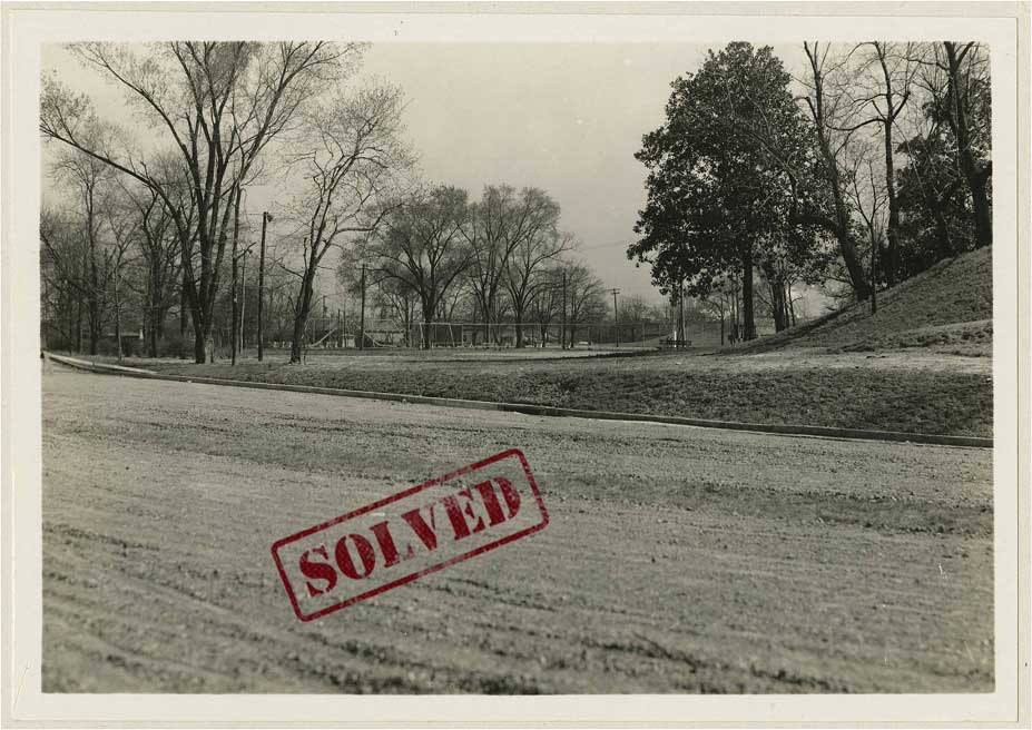
The back of this photograph indicates that it was taken along Cleveland Street on an undetermined date.
A Barber Shop to the left of the billboard can be seen, and we can also see a Motor Co. on the right. What area of Cleveland is depicted in this image? Do you know the time period?
SOLVED!!
A few people successfully located this spot by finding ads for McMullen Motor Company in the Commercial Appeal archives. Ads for McMullen Motor Co. first appear at the address 439 N. Cleveland in June of 1944. By mid-1948, advertisements begin showing Bob Erwin Motors at the same address. It is likely this photograph was taken sometime between 1944-1948.
So, where was the photographer standing? One detective noticed that by examining the photograph in Digital ID Street0902, you can see 439 N. Cleveland, along with the smaller building that houses the barber shop in our photo. Both buildings are on the southern side of Autumn Avenue, near the intersection with Cleveland. The image in Street0902, also shows a driveway of sorts that leads to a parking lot just west of the barber shop. This matches the road seen next to the billboard in our photograph. The building with the barber shop sign is still there today. That building is located at 1349 Autumn Avenue, which means we’re looking at the back of the building in our photograph.
The photographer was likely standing near the coordinates: 35.150500, -90.014101.
[expand title=”Click here to share additional details!”] — [/expand]
Explore more mysteries:

Resources:
Here are some resources that can help with your search.
City Directories 1849-1943 – Shelby County Registrar (link)
Commercial Appeal Archives 1894-Today – ProQuest(link)
Historic Shelby County – Aerial Maps (link)
Maps of Memphis (link)
Vehicle Registration Plates of TN – Wikipedia (link)